

Introduction
Material and Methodology
Neighborhood typology and morphological characteristics based on urban form and physical environments
Empirical analysis of the relationship between urban form and physical environment factors and residents’ walking behavior by neighborhood type
Results and Discussions
Findings on the classification and physical description of neighborhoods
Results of the impact of built environment elements on walking share using a robust regression model
Conclusions
Introduction
Contemporary urban areas are encountering a multitude of challenges. The use of fossil energy poses a threat to sustainable growth, as it contributes to climate change and environmental pollution. Urban planning that prioritizes automobiles has led to the loss of social functions in urban streets. Additionally, sedentary lifestyles have become a significant urban problem, giving rise to health issues like obesity and adult diseases. The debate of walkable cities is gaining momentum both domestically and internationally as a means to address urban challenges. The planning and design of transforming the current urban environment into a pedestrian-friendly environment is emerging as a crucial issue in the pursuit of creating a city that revolves around walking.
Prior to the mid-1990s, there was limited interest in studying the connection between walking behaviors and the physical environment in the urban and transportation fields. However, in the 2000s, there was a rise in interest and the exploration of subjects linked to walking behavior became more prevalent in these fields [1]. Specifically, research has been conducted on walking in the fields of public health and transportation planning [2]. Early investigations have examined the factors that impact the choice of transportation modes. This study tradition aimed to determine the characteristics that influence the transition from using a single-occupancy automobile to walking, biking, or using public transportation [1]. The comprehensive correlation between pedestrians and urban form can be attributed to the research of Cervero and Kockelman [3], who introduced the concepts of density, diversity, and design in reference to the San Francisco region in the United States. Subsequent research incorporated additional environmental characteristics derived from Cervero and Kockelman’s 3Ds, and expanded upon the existing framework for studying the connection between urban environment and transportation [3]. Lee and Moudon [4] introduced the concept of 3D+R, which encompasses density, diversity, design, and route. They argue that the built environment between the starting point and the destination is of significant relevance. Ewing and Cervero [5] expanded the initial 3Ds of density, diversity, and design by include distance to destination and distance to transit. This resulted in the identification of 5Ds of urban form that have an impact on walking. These research examined the correlation between environmental conditions and walking by employing the socio-ecological model and the Behavioral Model of Environment (BME) as the conceptual framework. Studies on walking in urban areas have been undertaken using several methodologies, depending on the specific objectives of the studies. Furthermore, there are other methodologies available for scientifically examining the correlation between walking and urban form. For instance, Cerin et al. [6], Park and Kwon [7], Park, Choi, and Seo [8], and Oh and Sung [9] develop indicators for diagnosing walkable environments. Notable studies examining the range within which pedestrians are likely to travel locally include Moudon et al. [10], Agrawal et al. [1], and Kim, Ahn, and Kwon [11]. Schulz and Northridge [12] and Kim et al. [13] examined the correlation between personal health and walking, while Kim and Yang [14] investigated the connection between walking and social capital. Significant studies examining residential location and attitudes to walking include Handy, Cao, and Mokhtarian [15]; Lee and Moudon [4]; Bhat and Guo [16]; Boarnet, Greenwald, and McMillan [17]. Additionally, there are studies that specifically investigate demographic groups such as the elderly, children, and women, including McDonald [18] and Napier et al. [19].
Nevertheless, prior studies on walking exhibit the subsequent constraints. Prior research has not consistently demonstrated the anticipated correlation between the urban physical environment and walking behavior. The impact of the physical environment on walking activities differs based on social and cultural factors, as well as the purpose of walking. Therefore, even similar environments can have varying effects on pedestrians, or the impact on pedestrians may differ due to significant differences in the study area’s context. Furthermore, there is an absence of discourse regarding the efficacy of theories formulated from Western cities when applied to Korean cities. This is primarily due to the divergent starting points of analysis resulting from disparities in the physical, historical, social, and cultural contexts between Western cities and Korean cities. Furthermore, past studies have emphasized the importance of high-density development and mixed-land use policies in shaping urban settings. However, there is a noticeable absence of discourse regarding the specific urban forms that promote pedestrian activity.
This study seeks to categorize urban areas (neighborhoods) according to morphological factors associated with walking, discern disparities in experiential qualities among different types, conduct a preliminary examination of residents’ walking behavior and activity patterns according to neighborhood type, and empirically validate the impact of neighborhood types and morphological characteristics on residents’ walking behavior and activity patterns. The final objective is to propose urban planning and design solutions that promote the creation of pedestrian-friendly urban spaces.
This study focuses on Seoul, Republic of Korea, and analyzes its administrative districts known as “Dongs”. While census tracks, which are smaller than neighborhoods, offer a more detailed level of analysis compared to Dongs, the latter is considered the appropriate unit of analysis for this research question due to the availability of residence information at the Dong level in the Household Traffic Survey data. Furthermore, the study focused on analyzing the Dong area in Seoul, which has a variable size ranging from 400 to 900 m, based on the specified pedestrian catchment area norm of 400 to 1,000 m. However, the study focused on the time of 2010. The cross-sectional data from this survey was utilized to create a comprehensive record of pedestrian traffic for individuals. If data for the year 2010 were not obtainable from sources other than the Household Transportation Survey, the data for the year that was closest to 2010 was utilized instead. Despite the Household Transportation Survey data being from 2016, the widespread use of personal mobility devices has created challenges in accurately identifying pedestrian movement. Consequently, we were required to utilize data from the year 2010.
The study’s content scope was divided into two main objectives. The initial objective was to classify the neighborhoods of Seoul based on their built environment and physical setting, and thereafter examine the morphological characteristics of each category. To achieve this objective, a typology technique was developed by examining urban morphology, theories connected to pedestrian-oriented urban design, and previous research. Subsequently, Seoul’s Dongs were classified using cluster analysis. The second objective was to empirically validate the presence of variations in walking indicators based on type, and to determine the extent to which the physical environment and urban morphology variables utilized in the typology influence walking behavior through statistical models.
Material and Methodology
Neighborhood typology and morphological characteristics based on urban form and physical environments
To categorize neighborhoods in 424 districts of Seoul based on urban form and physical environment indicators, a comprehensive analysis of relevant literature and theories was conducted. The urban form and physical environment variables were measured using ArcGIS 10.1, and cluster analysis was performed using R. The outcomes of the cluster analysis were systematically assessed to validate the disparities among the various categories of neighborhoods. The morphological parameters of each neighborhood type resulting from the cluster analysis were assessed numerically, and the disparities were empirically confirmed by qualitative examination. This study categorized the characteristics of land use and urban form into land use, street and building relationship, street structure, and road characteristics. To classify urban form and physical environment variables, spatial data provided by the Seoul Metropolitan Government and Statistics Korea were utilized.
Clustering analysis was employed to quantify land use and urban form variables and to divide and classify communities based on these variables. Clustering is an analytical technique that categorizes data into clusters of related elements, without prior knowledge of their specific cluster status. Cluster analysis can be classified into hierarchical clustering and partitional clustering based on the presence of sub-clusters inside a cluster. Hierarchical clustering involves the process of merging clusters from lower levels to generate higher-level clusters, known as agglomerative clusters. On the other hand, disjunctive clusters start at the top and split into several clusters as they descend. Partitioned clustering encompasses various clustering techniques, including prototype-based clustering, distribution-based clustering, density-based clustering, and graph-based clustering. Typically, the prototype-based K-means clustering technique is employed in partitioned clustering. In contrast, general clustering algorithms assign a cluster to every data point. However, when the data is located distant from the cluster center or near the cluster boundary, it becomes uncertain to assign it to a particular cluster. Nonetheless, the algorithm still attempts to assign it to a certain cluster based on calculations. Fuzzy clustering is a form of clustering that permits individual observation data to be assigned to several clusters and provides the probability of belonging to each cluster as a measure of certainty. It can address the limitations of hard clustering, which are evident in K-means clustering.
Empirical analysis of the relationship between urban form and physical environment factors and residents’ walking behavior by neighborhood type
This study aimed to empirically examine the influence of neighborhood type and morphological characteristics on residents’ walking patterns. The analysis involved classifying neighborhoods based on cluster analysis, taking into account urban form factors such as the spatial matrix of building coverage ratio and floor area ratio. To achieve this objective, we calculated the mean values of walking time, the number of walks, and walking mode share for residents in different types of neighborhoods. We used data from the Household Transportation Survey and compared the walking behavior of each neighborhood type through an analysis of variance (ANOVA). Furthermore, to assess the impact of specific variables related to urban form were determined using a robust regression model. The model used walking share as the dependent variable and built environment variables as explanatory variables.
Results and Discussions
Findings on the classification and physical description of neighborhoods
Applying the fuzzy clustering method to the spatial matrix of building coverage area ratio and floor area ratio is a reasonable and beneficial approach to determine the types of neighborhoods based on urban form in the 424 neighborhoods of Seoul (see Figure A1 and A2). Additionally, utilizing clustering analysis with the spatial matrix of population density and mixed land use can provide supplementary information on land use characteristics. There are five distinct types of clusters that can be identified. The first type, C1, refers to dense areas that consist of single or multi-family residences and have good permeability. The second type, C2, refers to large-scale apartment complexes that are built in superblocks and have a higher OSR index. The third type, C3, refers to apartment areas that have mixed land uses. The fourth type, C4, refers to dense areas that consist of single or multi-family residences and have an organic urban organization. The fifth type, C5, refers to mixed types of clusters that consist of both single or multi-family residences and apartment. These types are illustrated in Figure 1. Morphological disparities among clusters were identified by a comparison of the distinctive neighborhoods within each cluster, taking into account architectural features, street layout, land use, and the number of building stories. The fuzzy cluster analysis identified the top neighborhoods by evaluating their likelihood of belonging to each cluster, thereby providing insights into the key morphological characteristics of each cluster. The one-way ANOVA findings indicated substantial differences in the means of population density, mixed land use (Entropy index), intersection density, road density, block size, OSR index, and apartment ratio across the five clusters (Table 1).
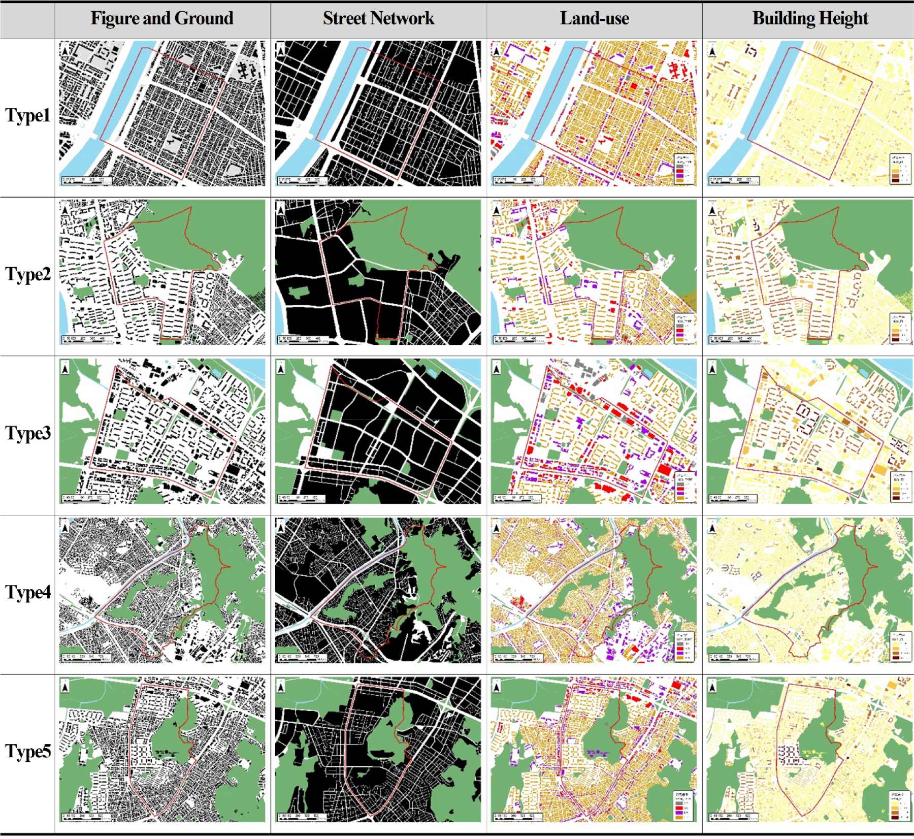
Table 1.
Differences in built environments between clusters by one-way ANOVA analysis
2) Differences in built environment by cluster were tested by one-way ANOVA. However, since the cluster analysis was performed with building coverage ratio and floor area ratio, building coverage ratio and floor area ratio were excluded, but statistically significant differences were found in the one-way ANOVA.
To empirically confirm the variations in walking performance among different cluster types, a one-way analysis of variance (ANOVA) was performed. Walking performance indicators were established for each cluster type (see Figure 2). The walking performance indicators were assessed by transforming the data from the Household Transportation Survey from means to ends and aggregating it by 424 neighborhood areas. The indicators were the walking share rate, average walking time, and average walking frequency. The research revealed a substantial disparity in the walking share rate based on urban configuration type (p-value=0.647 according to Bartlett test / F-value=7.359, p-value <= 0.001 according to one-way ANOVA). After confirming the statistical significance of the difference in the walking share rate among the urban configuration types, we conducted a post-hoc analysis using Chappe’s test to examine the variations within each cluster. The analysis shows that the walking share rate is higher in single/multi-family dense areas (C1) with a grid-like layout that allows for good permeability, compared to mixed-use apartment areas (C3), with a difference of 7.5% (p-value=0.0003). Similarly, large-scale apartment complexes (C2) built as superblocks have a higher walking share rate than mixed-use apartment areas (C3), with a difference of 8.9% (p-value=0.0004). Single/multi-family dense areas (C4) with an organic urban form are 5.0% (p-value=0.073) higher than mixed-use apartment areas (C3). Lastly, mixed-use residential areas (C5) have a 5.4% (p-value=0.049) higher walking share rate than mixed-use apartment areas (C3).
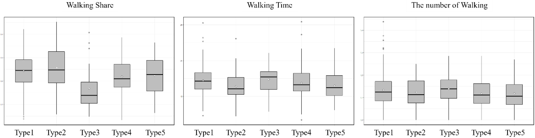
Conversely, there was no variation in the average duration of walking, or the frequency of walking based on the five neighborhood types. The mean walking time exhibited statistical significance, as indicated by an F-value of 2.961 and a P-value of 0.0197, based on the one-way ANOVA. However, the post-hoc test conducted by Chappe revealed that the variation in walking time across different clusters was not statistically significant. Therefore, it was concluded that there is no discernible difference in walking time based on neighborhood type. The mean number of walks did not show a statistically significant difference, as indicated by an F-value of 1.331 and a P-value of 0.258 in a one-way ANOVA.
Results of the impact of built environment elements on walking share using a robust regression model
A robust regression analysis was used to investigate the impact of the built environment on walking behaviors (see Table 2). The study examined different physical environmental characteristics as explanatory variables, with the walking mode share being the dependent variable. The findings highlighted the importance of various aspects, including the residential location, the density of the population, the mixed land uses, the accessibility to commercial facilities, the average ratio of building coverage area, the distance to subway stations, and the age of buildings, especially those that are more than 20 years old.
Table 2.
Robust regression analysis of built environment factors affecting the walking share
A significant discovery was made regarding the favorable influence of the average coverage area ratio in residential areas on the proportion of people who choose to walk. This trend indicates that a higher covered area ratio, which frequently leads to direct building access from the street and a variety of building types, promotes pedestrian activity. Moreover, this outcome underscored the need of incorporating a combination of land use and population density to enhance the appeal of walking. These characteristics enhance the cost-effectiveness of walking by enhancing local accessibility and diversity, thereby rendering walking a more feasible and attractive choice.
Surprisingly, although the accessibility of commercial amenities was shown to be important, the existence of a combination of different types of land use within residential neighborhoods had a stronger impact in promoting walking. This discovery is consistent with the ideals of New Urbanism, which promote a greater concentration of people and a diverse range of land uses in order to minimize travel distances and enhance the accessibility of facilities.
Another significant observation pertained to the impact of urban form and public transit. The investigation indicated that there is a positive correlation between improvements in urban design, such as buildings with various sides facing the street, and an increase in the proportion of people choosing to walk. This architectural approach enhances the ease of access to buildings, hence promoting pedestrian movement. Within the context of Seoul, the degree of ease in reaching subway stations was discovered to have a greater impact on the percentage of people who choose to walk, compared to the accessibility of bus stops. This emphasizes the significance of the subway system as the principal means of public transit.
Furthermore, the study revealed that older areas, distinguished by buildings that are more than 20 years old, tend to have a greater proportion of people who walk as their mode of transportation. This can be ascribed to the more organic and pedestrian-friendly urban structures of older projects in contrast to modern, more meticulously designed ones. Nevertheless, Seoul displayed regional disparities, as the southeastern region demonstrated a lower proportion of walking compared to the city center.
This finding demonstrates that although high population density and a diverse mix of land uses are significant factors in urban planning to promote walking, the physical connection between streets and buildings is as essential. This indicates a requirement for urban designs that promote the closeness of buildings to streets, therefore encouraging the creation of more pedestrian-friendly surroundings. These findings make a substantial contribution to the existing body of knowledge on urban planning, specifically in terms of understanding how various elements of the physical infrastructure might be adjusted to encourage walking as a mode of transportation.
Conclusions
The objective of this study is to build a morphological typology of urban areas and develop a method to evaluate walking performance for each type. The typology methodology was devised by examining theories on urban morphology and existing research. Following this approach, typology was pursued by means of cluster analysis utilizing diverse spatial data. Subsequently, the distinctive physical attributes of every type of neighborhood were assessed using qualitative and quantitative techniques. Furthermore, the variations in walking ability among different types were examined through the establishment of walking performance indicators. Furthermore, the variables employed in the typology were empirically validated by the establishment of a statistical model aimed at determining the significance of the walking performance indicators.
This study has made significant contributions to the advancement of research in related domains in the following manners. Initially, it mitigated the reductionist fallacy in pedestrian studies and also established the basis for a holistic approach to pedestrian research focused on spatial variables. Current pedestrian studies primarily aim to validate urban physical environment factors that promote walking. However, it is important to acknowledge that the walking environment is shaped by a combination of individual factors. Therefore, it is possible that reductionist errors may occur, neglecting the holistic nature of space. This study aimed to classify urban areas based on land use and morphology, and to address the limitations of previous studies by examining variations in pedestrian activity levels based on different types of urban areas. Furthermore, this study confirmed the impact of building coverage ratio and OSR index on walking within urban blocks. The configuration of urban areas is shaped by the interplay of buildings and urban blocks, which can be quantified using metrics such as coverage area ratio, floor area ratio, building height, and OSR index. Given the association between the four factors, it is evident that the urban form may be well represented by the coverage area ratio and OSR index. Consequently, we incorporated the urban form variable into the existing pedestrian research model to examine the impact of 5Ds + coverage area ratio and OSR index. The importance of this study lies in its development of urban form-related variables that were not previously explained in other studies, and then confirming their impacts.
Within the realm of both domestic and international pedestrian study, this research project’s findings carry the subsequent implications. Unlike the issues faced by Western cities, the problems in Korean cities should prioritize the examination of urban form conditions in densely populated areas to promote walking. By taking into account the previously overlooked urban morphological characteristics, we have classified neighborhoods and conducted empirical research to validate their impact on walking. Furthermore, this study provides a novel perspective by examining the variations in walking performance across different types. It highlights the significance of considering the entirety of the urban environment when designing pedestrian-friendly spaces, thereby addressing the limitations of previous research that focused on isolated factors. Additionally, it validates the efficacy of the factors proposed in earlier studies by assessing their compatible integration. Nevertheless, this study specifically examines the neighborhood unit in Seoul, and does not account for external factors beyond land use and urban form. As a result, the explanatory capacity of the empirical model is constrained. To ensure the success of the future study, it is important to construct comprehensive spatial big data at the census track level and conduct empirical analysis using an advanced model.


