

Introduction
Material and Methodology
Result and Discussions
Social and economic sustainability
Conclusions
Introduction
The regulatory scenario outlined by the European Union, related to the themes of the Green Deal [1], tries to imagine the infrastructure of public spaces as a crossroads of cultures that live in time and operate in space. Within this vision, the contribution aims first to restore the values and the national and international guidelines from which the project hypothesis is developed. The contribution then delves into the tools and methods of inter-scalar analysis, aimed at responding to the European need to verify the contemporary performance requirements of systems of infrastructural mobility and management of the highly densified built environment. Aligning itself with the evolving needs of users while respecting the identity value of the sites [2], the experimentation describes a design hypothesis of sustainable development and environmental protection of infrastructural mobility in the Sorrento Peninsula. It has been conducted within a competition announced by the Rotary Association in accordance with the new forms of bottom-up design [3]. Finally, in order to generate replicable strategies in contexts characterised by the same criticalities, the contribution returns a multidimensional recovery model that rearticulates the interrupted connections between the built environment and infrastructures. This makes it possible to produce a sustainable vision of coastal cities with a high population and tourist density that responds to the regulatory scenario outlined above.
The contribution provides an advancement in the European debate on experiments in built environment heritage rehabilitation, understanding the latter as a resource for the transition of cities [4]. In fact, the contribution is aimed both at progressing and enhancing the quality of the built environment [5], projecting towards the latest Regulations of the European Parliament in relation to the establishment of the European Year of Cultural Heritage [6] and the New European Bauhaus [7]. The same model incorporates the guidelines of the United Nations 2030 Agenda for Sustainable Development [8] in order to link land management processes to an inclusive, sustainable and systemic dimension of the built environment [9].
Within the European sustainability guidelines, the adaptive reuse of mobility infrastructure is a necessary requirement, considering the increase in the anthropogenic greenhouse effect (Global Warming Potential - 100 years). It is itself the cause, whose impact is measured on the amount of CO² emissions into the atmosphere generated by the consumption of energy and matter in its own life cycle [10]. At the same time, however, the loss of infrastructure leads to the decommissioning of the urban surroundings and the consequent degradation of the built environment, producing both a significant environmental impact and a decrease in the cultural, social and economic value of the site. As recalled by both the legal status of the European Landscape Convention, the Codice dei Beni Culturali and the reform of Title V of the Italian Constitution [11], mobility infrastructure indicates the delimitation of administrative districts as well as the demarcation of territorial signs of the landscape [12]. In such a scenario, the rehabilitation of infrastructures and sites representative of disused cultural heritage represents a potential resource for the experimentation of sustainable territorial systems capable of enhancing and producing environmental, economic and cultural capital to be transferred to future generations [13].
Material and Methodology
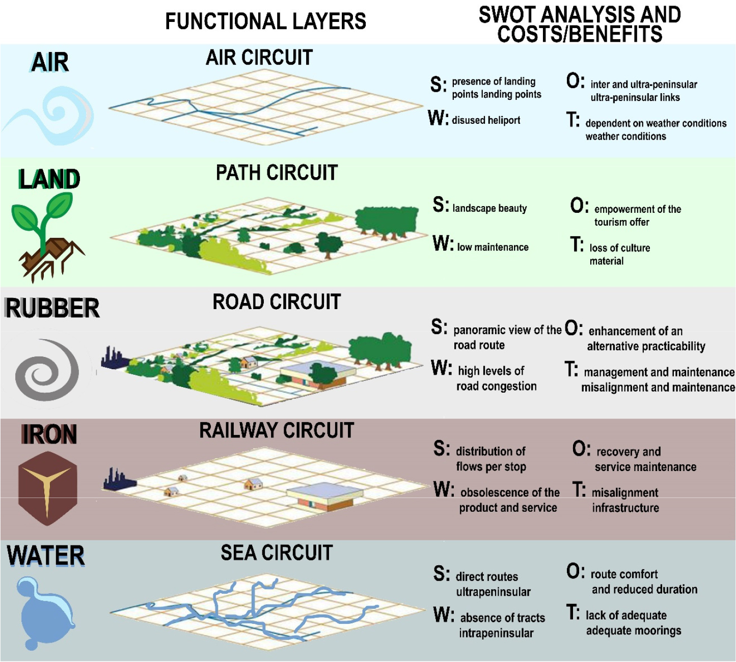
The methodology proposed to support the construction of the design hypothesis that combines the systemic and performance approach with the need to respond to the needs of urban transition and growth [14]. From a cross-analysis perspective, this allows for the identification and transformation of the disruptive pressures affecting the built environment, integrating multifunctional addresses to social and ecological components [15]. With reference to the latter, the design idea traces a correspondence between the type of mobility identified and the primordial element to which it refers, determining the identification of mobility circuits to be recovered and regenerated in a sustainable way [16]. Thus, the air mobility system has corresponded to the element of air, the trail mobility system to the land, the road mobility system to the rubber, the rail mobility system to the iron and the maritime mobility system to the water [17]. This association of circuits and elements is intended to signify the desire to overcome the presence of limits between the built city and the environment: in the city and in contemporary society, mobility systems are strongly linked to urbanisation phenomena, which constantly redefine the environment/climate and society/market relationships [18].
This discretization made it possible to analyse each typological mobility circuit according to the methodology of the SWOT Analysis, by means of which to bring out the degradation of services and territorial dissymmetry on which to act for the rebalancing of the well-being conditions of the built environment and the communities that inhabit it [19].
The mobility system as an infrastructural service composed by city crossing layers, turns out the need to reconnect and functionally integrate the different circuits in order to exploit the potential of one system where those of another are lacking [20]. Through the creation of a sustainable network of coordinated mobility layers, it is possible, on one hand, to act on the indicator of territorial well-being, putting in synergy the social and economic dynamics of a community within the exchanges with the services of the territory [21]. On the other hand, to stimulate the strengthening of new relationships with the landscape/cultural heritage in order to improve the quality of life [22]. This has an impact on the identities of the communities settled in the area, which recognise themselves as belonging to it, in a sort of network of overlapping heterogeneous and complex components (Figure 1).
To strengthen the multi-level systemic proposal, the project hypothesis applies to the model a principle of circularity of mobility circuits, borrowed from Life Cycle Assessment (LCA). The latter allows building an analytical and systematic approach around the aggregative and integrative functioning of individual mobility systems [23]. The planning hypothesis evaluates the environmental footprint of a mobility system (both in terms of service and in terms of product) along its entire life cycle [24]. The calculation allows us to plan the rehabilitation and regeneration of mobility systems from the extraction phases of the raw materials making up the circuit, to its construction, operation and final disposal, returning the environmental impact values associated with its life cycle (Figure 2).
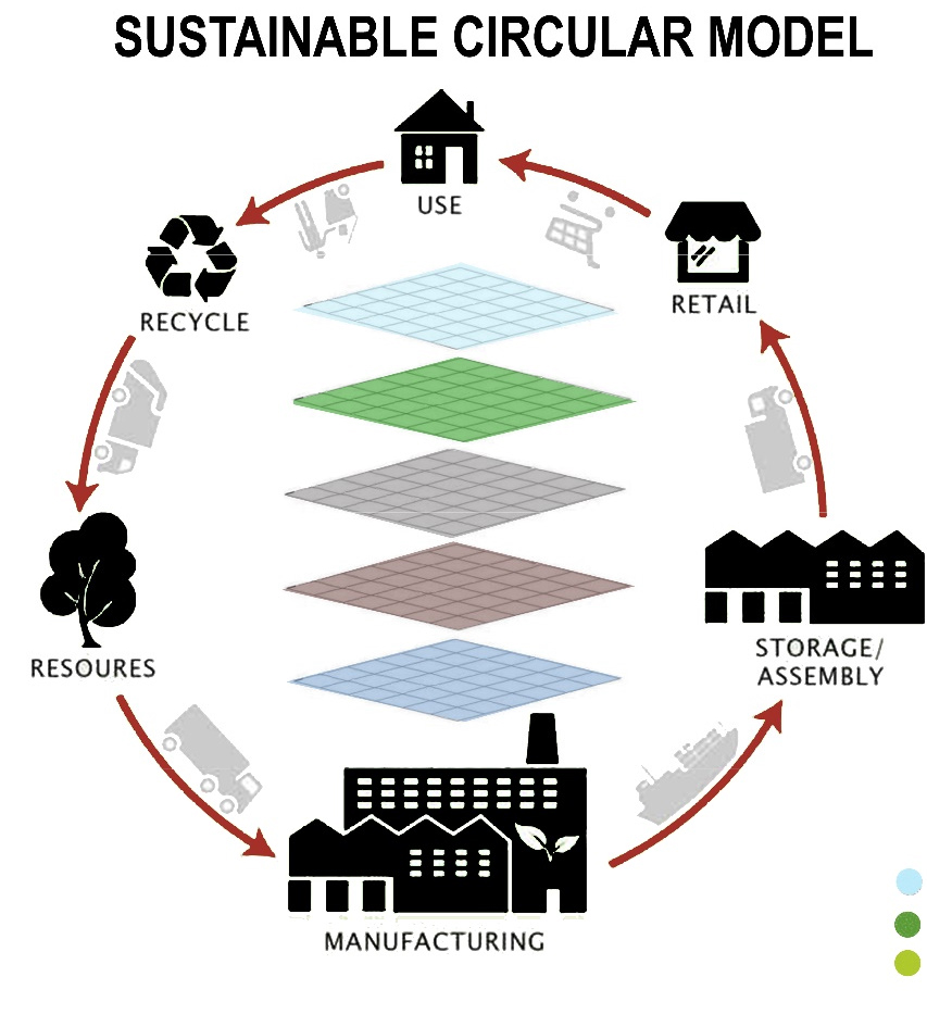
The ecological footprint of the mobility system is accounted for through the impact of everything needed to provide that same service [25, 26].
Result and Discussions
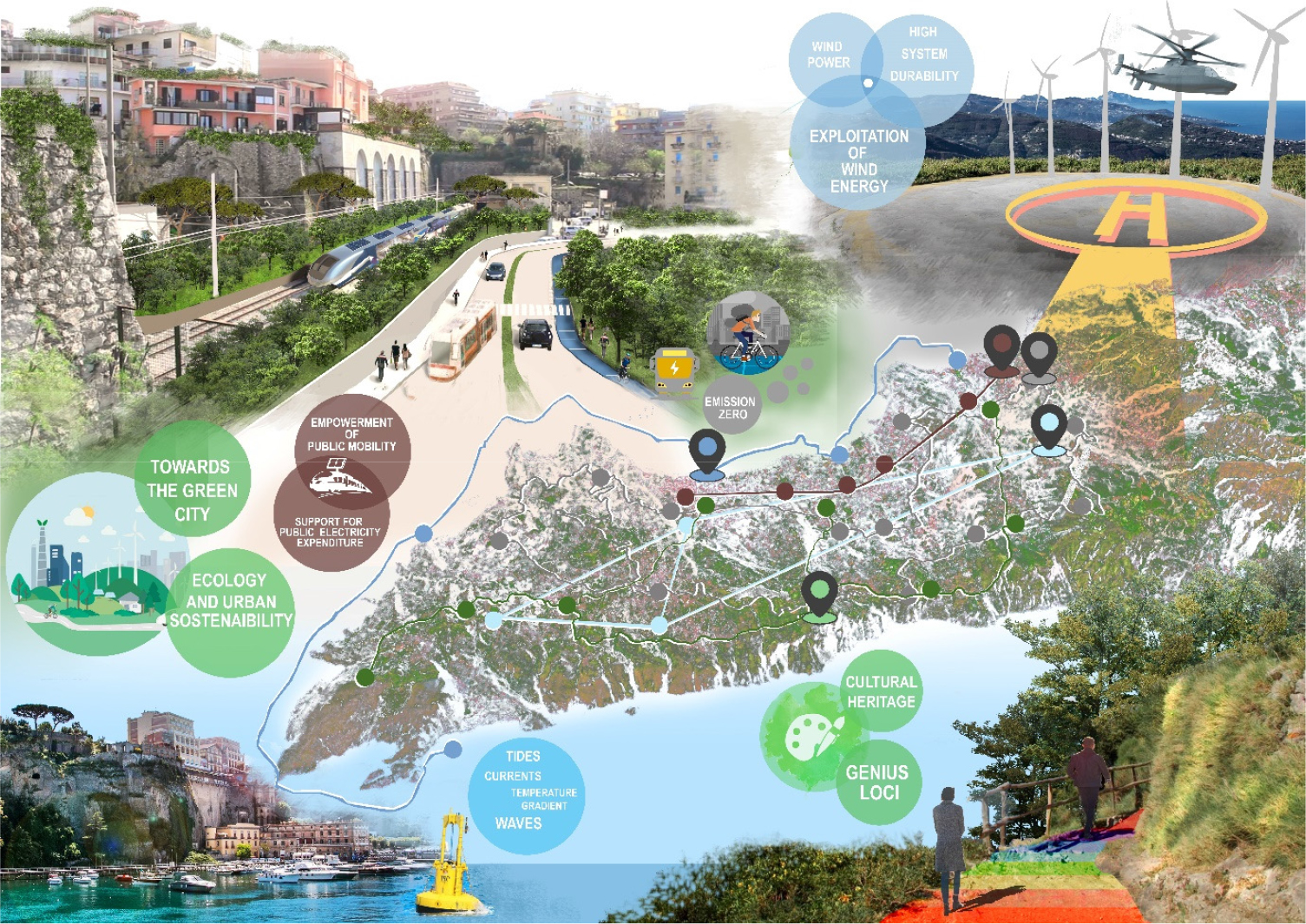
The project hypothesis uses the criticalities characterizing the connection circuits (air, sea, rail, road and pathways) as an opportunity to renew the territorial strategies. The proposal recovers and requalifies the pre-existing infrastructural systems integrating new ones, in order to look at the contemporary condition of the territory. Intervening on the mobility systems of the territory of the Sorrento Peninsula means carrying out urban transformations capable of modifying common urban spaces and affecting the development of new forms of landscape. The latter, in its fragility, encloses both the aesthetics of a territory of extraordinary landscape value and the custody of the genius loci and the collective identity of the peninsula.
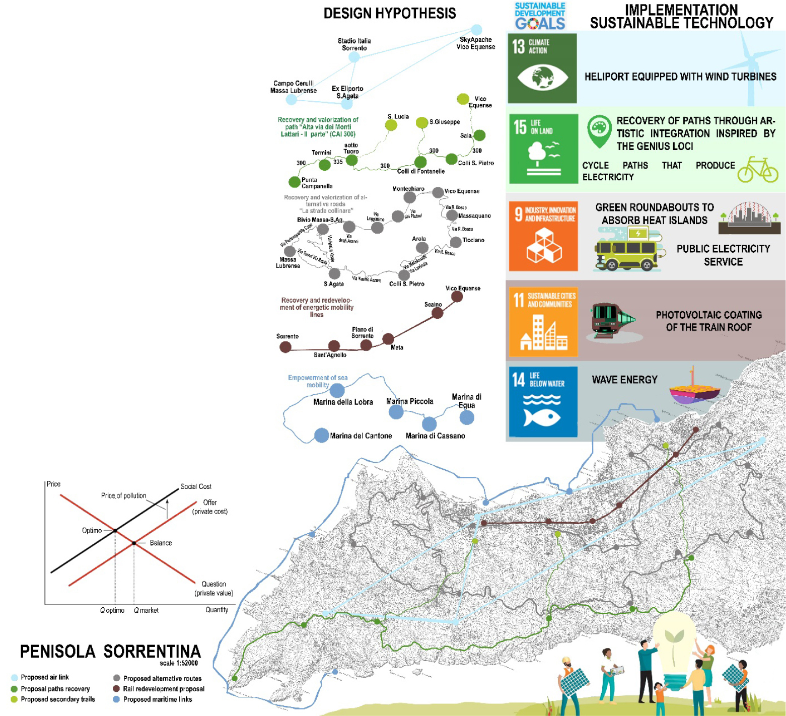
In an intercalary and multidimensional vision, the project hypothesis can be returned through the proposal of a solution for each type of mobility on a territorial scale; the correspondence of the identified proposal with a specific European Sustainable Development Goals; the combination of the same proposal with an implementation solution on a technological scale for detailed sustainable development.
The hypothesis was built through 5 SWOT matrices, each for the respective mobility infrastructure.
For the Air Circuit, the strengths were identified as the presence of suitable landing sites for small and medium-sized helicopters. The weaknesses were identified as the presence of disused areas previously used as helipads; the opportunities were identified as the possibility of establishing inter- and ultra-peninsular links; the threats were identified as the dependence of the link’s operation on weather conditions.
The strength of the Path Circuit lies in the beauty of the landscape that characterizes the places to be explored. The low level of maintenance of these routes is a weakness; the possibility of facilitating and enhancing the local tourist offer through their recovery is an opportunity; the potential loss of the material culture of the sites in the absence of coordinated interventions is a threat.
For the road network, the strength is the panoramic nature of the existing road network; the weakness is the high level of road congestion; the opportunity is the strengthening of a secondary and alternative route that is little known; the threat is the misalignment in the management of flows, and consequently of traffic, and the poor maintenance of existing routes.
For the Railway Circuit it has been identified as a strength point the distribution of flows per stop in consideration of the proximity of the stations of the municipalities that make up the Sorrento Peninsula. As a weakness point the obsolescence of the service and of the mechanical and technological products used. As an opportunity point the possibility to recover and maintain the service through an adequate management aimed at energy efficiency; as a threat point the infrastructural misalignment between the railway service and all the others present (with specific reference to the public road service).
For the Maritime Circuit, the strength is the existence of direct ferryboat routes that allow for connections with the Province and nearby islands. The weakness is the absence of inter-peninsular ferryboat routes for the decongestion of tourist flows; the opportunity is the comfort of travel and the short duration of the routes; the threat is the lack of adequate existing docks.
The project hypothesis in resolution of the discretised criticalities foresees for the air mobility system the dislocation on the territory of 4 landing points. The quantity of the number of heliports proposed has been determined based on the capacity to cover the catchment areas with respect to the internal peninsular area. On the other hand, the location of the heliports has been determined on the capacity to cover possible emergencies on both coasts of the peninsula (locating the sites on the main territorial ridge). The hypothesis foresees the rehabilitation of the pre-existing heliport and its connection both with a currently existing one and with the requalification of strategic rescue sites such as the stadiums of some municipalities. Of these 4 heliports, two of them lend themselves, for orographic and altimetry vocation, to the technological implementation of the site through a system of wind turbines. In fact, these two heliports, being far from urban centers, can be regenerated through the construction of platforms for take-off and landing and through the creation of facilities for shelter and measurement of wind force. The air transportation system would work in compensation to the wind turbines because, in high wind conditions, the absence of mobility operation would be compensated by the gain of clean energy. In addition, the strengthening of the circuit of aerial mobility would represent not only a system of facilitation of movement but also a garrison of emergency mobility and territorial control and would offer a new form of tourism in terms of landscape offer. This project hypothesis is in line with SDGs 13 whose objective is to promote actions at all levels to combat climate change. Specifically, this project hypothesis can be identified in section 13.1, which concerns the strengthening of the capacity of all countries to recover and adapt to risks related to climate and natural disasters [27].
The project hypothesis for the enhancement of the path mobility system provides for the rehabilitation and enhancement of the CAI 300, reactivating a specific stretch of secondary walk roads, present in suburban contexts, it is possible to make the pedestrian paths identified garrison of accessibility to places with landscape value. Recovering the paths represents an opportunity to reactivate the territorial security and guide the management and maintenance of the landscape. In addition, the regeneration of trails promotes the protection and enhancement of local cultural identity. The paths, in fact, represent an exceptional element to support the sustainable use of the landscape. The hypothesis, specifically, identifies two typological ridges of paths: a main one that connects all the villages of the Sorrento Coast in the most significant and panoramic places; three secondary arteries that interrupt the main one and that lead to the inhabited centers. The decision to enhance these specific paths comes from having attributed to these routes a particularly high and little known constructive meaning: in these places, the action of man has contributed to obtain landscapes of excellence, which have strongly characterized the territory, the quality of agricultural production and the ecological balances. These aspects support the construction of an identity and a recognizable landscape able to develop economies of excellence as well as preserve the safety and permeability of the soil (reducing flood risks, erosion phenomena and environmental degradation). In addition to the instances of identity and culture, the project hypothesis proposes the inclusion in these paths of artistic works inspired by the genius loci and myths of the Sorrento Peninsula narrated by Homer to implement the fruition and to consolidate the community cultural instances. The main backbone aims to be an itinerant driver of tangible and intangible resources that the paths can offer according to the principles of slow mobility and cultural and sustainable tourism. On the contrary, in the secondary ridge, less wild and closer to the urban dimension, it was assumed the inclusion of a bike lane in the last sections overlooking the municipal centers. The hypothesis is that of a section about 250 meters long and equipped with grids of 1.5/2.0 meters. The rideable surface is made of approximately 1 cm high sections of transparent tempered glass, which laid directly on top of the grids. The structure of the track is slightly inclined, to allow the drainage of water during rainy days. The runway has a translucent surface to allow the maximum possible absorption of light. At the same time, the surface glass is designed to be non-slip and to withstand even heavy weights. Considering that 150,000 cyclists can generate about 3,000 kilowatt-hours, the achievable energy load would be enough to power a home for an entire year. This could be a form of support for the sustainability of public lighting. This project hypothesis is in line with SDGs 15 whose goal is to protect, restore and promote sustainable use of the Earth’s ecosystem. Specifically, this hypothesis can be identified in section 15.4, which aims to ensure, by 2030, the conservation of mountain, forest and hillside ecosystems, including their biodiversity, in order to improve their capacity to produce benefits essential for sustainable development [27].
The design hypothesis for the enhancement of the road mobility system provides for an alternative road system that works to enhance the two already existing ones that, tying them together, determine the creation of a complete and complex road circuit. The selection of these roads has been made both based on the identification of the fastest alternative route, supporting the existing ones, and based on the possibility of integrating traffic circles and urban green areas aimed at absorbing the heat islands typical of very busy coastal areas. In urban centers in summer, often, this microclimatic phenomenon occurs that involves a local overheating with an increase in temperatures up to 4-5° compared to the peripheral areas. In addition to this type of pathway is associated with a plan of public services electrically operated that would take advantage of a service of electric columns placed as a recharge from public lighting. The public electric mobility would boast a vehicle autonomy of about 50 km restored daily by the electrical network. This would allow not only the reduction of traffic but also the decrease of smog pollution.
This project hypothesis is in line with SDGs 9 whose objective is to build a resilient infrastructure and promote innovation and a fair, responsible and sustainable industrialization. Specifically, this hypothesis can be identified in section 9.1 which addresses the development of quality, reliable, sustainable and resilient infrastructure - including regional and cross-border infrastructure - to support economic development and the well-being of individuals, with a focus on equitable and affordable access for all [27].
The design hypothesis for the enhancement of the rail mobility system includes redevelopment of both service and existing stop rail products. The service redevelopment includes a new scheduling of trips by proposing 5 additional intra-peninsula trips per day (morning, noon, early afternoon, late afternoon, evening) in order to limit the use of vehicles on the road. In addition, the hypothesis provides for a programmed offer of trips during the tourist season in order to connect the Peninsula with the particularly significant cultural sites distributed throughout the territory. The redevelopment of the product also includes a maintenance plan with artistic integration inspired by the identity of the place for the redevelopment of the stations, now also a tourist attraction. It is also assumed the technological modernization of the wagons through the photovoltaic coating of the covers of the trains. Each train (consisting of 3 cars) would have the capacity to integrate 16000 solar panels capable of producing each year, 3, 5 MW of electricity. This project hypothesis is in line with the SDGs 11 whose goal is to make cities and human settlements inclusive, safe, resilient and sustainable. Specifically, this hypothesis can be identified in section 11.2, which aims to ensure access for all, by 2030, to a safe, affordable, accessible and sustainable transport system, improving road safety, enhancing public transport, with particular attention to the needs of those who are most vulnerable [27].
The project hypothesis for the strengthening of the maritime mobility system foresees the requalification of the Port as the main fulcrum of branching of tourist hydrofoils towards further 4 ports with a high transformative potential. The choice of the other ports has been based both on the identification of places that, geographically distributed, are able both to accommodate large areas of user flows in a homogeneous way and for their predisposition to port urban transformations for the creation of piers or minimum docking places without the harbour processing of the sites. This type of service would drastically reduce summer traffic due to the difficulty of reaching the main bathing areas. The redevelopment of these sites would also include the programming of a flotation system aimed at harnessing wave energy, which would work in a complementary manner to the port service. It would exploit not only the energy that hydrofoils normally produce, but in case of strong sea storms the system would be able to produce, despite the interruption of maritime links, electricity by exploiting the levels of wave motion. This project hypothesis is in line with SDGs 14 whose objective is to conserve and use in a sustainable way the oceans, seas and marine resources for sustainable development. Specifically, this hypothesis can be identified in section 14.7 which aims to increase, by 2030, the economic benefits of small island developing states and least developed countries through more sustainable use of marine resources, including sustainable management of fisheries, aquaculture and tourism [27].
The project hypothesis guarantees communication and collaboration between the different circuits: the functioning of one mobility, in fact, fulfils a specific need for movement while reducing the load of the flows of the other circuits with which it shares the functioning of the entire Sorrento Peninsula. The hypothesis, in fact, transforms the site into an infrastructural park on a territorial scale in which the logic of interchange and integration of transport modes allows new ways of sustainable development. Each mobility system in fact not only brings with it an innovative load from the ecological point of view, through the integration of sustainable technologies, but at the same time becomes itself a promoter of new forms of tourism. The proposed hypothesis works, on the one hand, preserving the livability of citizens and guests and, on the other, protecting the natural and landscape elements that distinguish the Sorrento Peninsula in the world. This generates a reticular model that involves not only the built and natural environment but also the social one, so that the participation of the users of the territory becomes an instrument of compatibility verification for the reuse of the recovered infrastructures. The reactivation of the different types of mobility, at the different levels considered, allows to protect the cultural identity of the sites and to generate, at the same time, new values attentive to the needs of time (Figure 3).
The proposed hypothesis focuses on the need to increase mobility in the territory in order to validate its economic and social sustainability. The proposed infrastructural mesh tries to connect distant and non-communicating parts of the territory and with it also the communities that live there, strengthening the channels of communication and movement. The hypothesis described is flexible to the needs of the users, adaptable to the requirements of the territory and open to the new challenges of sustainable research. It focuses on a shared identity, the pivot from which to regenerate the cultural values of the landscape of the Sorrento Peninsula. The hypothesis holds together the result of two components, the natural and the technological, in a virtuous process that has not altered the balance of the elements that make up the territory but has been enhanced through the systemic choice of points to recover in order to intervene on the vulnerabilities of the territory. The experimentation puts the rehabilitation process in the condition of enhancing the single emergencies by reactivating networks and mobility circuits as testimonies of the sediment settlement culture. These links are able to produce widespread benefits for the community and the urban context within the virtuous network generated by their reuse. The same sites to be reactivated to create new mobility systems have also been identified through the values that the community attributes to those places. The connotative constructive characteristics and the specificities of the genius loci represent the discriminating factors in the selection of mobility circuits. The latter have been recognised as having the capacity to be custodians of the perceptive-cultural values that the community invests and revises in those spaces interpreted as evidence of the tangible and intangible capital of collective identity [28, 29, 30].
From the administrative point of view, the hypothesis moves transformations in the short and medium-long term: on the one hand, through the setting up of tables of consultation between the major territorial decision makers, on the other in the creation of an ideational tool to support the planning and governance of the transport system of the Sorrento Peninsula.
Social and economic sustainability
From an economic point of view, the proposed hypothesis is based on the offer of an integrated system, with a consortium manager, which provides for the interconnection of air, land, sea, rail and road. The redevelopment of the heliport sites, the metropolitan railway network, the strengthening of the sea metro line, the network of integrated tourist trails and the improvement of the road network support the main factors that synergistically attest to the creation of a cohesive mobility system capable of producing efficiency both in the short range and at the interchange points. The increased traffic potential hypothesised in the proposal would make it possible to prefer the choice of public transport, which, with reduced time and expensiveness, would be advisable compared to private transport (the main cause of congestion in the peninsula).
From a social point of view, the mobility system hypothesis aims to maximise the well-being of resident communities and land users. For this reason, the hypothesis proposes to obtain the total surplus derived from the market when the demand curve intersects the social cost curve. The community, therefore, can be involved within the decision-making processes not only as a common knowledge able to identify and enhance identity places but also as a custodian to be educated on the ecological and protective aspects of the territory. The community is involved within the mobility system hypothesis in the condition of being an activator of a desirable future, focusing on the synergy and hybridisation between heritage protection, innovation, creativity and culture (Figure 4).
The recovery and management of the built environment can therefore intervene to mitigate the processes of abandonment and degradation in the technological sense of infrastructure systems. In fact, service systems can act not only to improve buildings but also lifestyles, prolonging their use and enjoyment with significant impacts on the environment and the modus vivendi of the community. In the light of the latest pandemic emergency, this type of intervention offers a new way of living which, on the one hand, mitigates the degradation of the built environment and, on the other, increases the cultural, environmental, social and economic value of the recovered infrastructure in the area. In particular, the technological culture of reclamation is closely linked to that of sustainability in that they aim to promote actions to keep the value of the available environmental, urban and building capital constant over time, to be transferred, together with the cultural capital, to future generations. Designing sustainable interventions means developing dedicated solutions, according to the identity and functional specificities of the building, and the economic, social and cultural contexts of reference. In this scenario, the theme refers to an approach that combines conservation and transformation actions, assessing their impacts on the cultural, social, economic and economic dimensions. The infrastructures of consolidated settlement systems are extraordinary examples where the coexistence of the values expressed by these dimensions requires the governance of the conflicts that may be generated. At the same time, the protection of the quality of the built environment of coastal cities marks the need for actions oriented to guarantee the efficiency of the performance of the built environment as a strategy for the enhancement of existing resources. The recovery project is developed starting from the comparison between the need for evolution of settlement systems, which being dynamic follow an increasing temporal evolution, and the infrastructural load that a physical system of the built environment has to face. The need to satisfy community and market needs can follow sustainable logics as demonstrated in the paper through multi-scalar strategies of recovery and regeneration. The proposal of the paper therefore reveals the need to use models and tools to evaluate and control design choices in relation to the demanding levels required by the use, the compatibility of the function to be settled, the reliability of the technological elements, their suitability for management and maintenance.
Conclusions
The project hypothesis allows widening the view towards the contemporary needs, constituting an interpretative device able to affect the spaces and the fragmented portions of the territory where nature offers potentialities of rehabilitation and regeneration. The proposed mobility system, in its different scales and types, aims to ensure accessibility, perception and crossing of the spaces of the territory. The mobility infrastructure, transforming itself in its long term, modifies the micro-histories of the places it relates for its own function. According to this vision, the design hypothesis considers, on the one hand, the beauty of the landscapes and sites of exception with which it is confronted and, on the other, the infrastructural plurality branched by heterogeneous components. The latter are, often, conflicting in mobility systems as the action of man, who tames nature, covers the traces of urban stratification. The research has presented a methodology of approach to the consolidated centers of coastal cities, whose housing and tourist density affects the degradation of the built environment and the capacity of the mobility infrastructure. The recovery of the different circuits, allows in a systemic perspective, to reactivate the cultural heritage considering it as a resource and no longer as a waste of an overloaded urban system. The ability to trace the identity values of the resident community in the infrastructural tracks allows experimenting a sustainable strategy of rehabilitation at different scales.
The innovativeness of the results is inherent in the ability to act simultaneously by modifying the order of several infrastructures from the transformation of a technical element upgraded or an entire network to support a renewed sustainable development. The strategy sees in the overlapping of infrastructure meshes the ability to rebalance settlement loads and urban pressures.
The research opens up to potential developments that see in the replicability of the model the possibility of generating a system of circuits on a metropolitan, regional and national scale to experiment with renewed and sustainable forms of inter-scalar rehabilitation.
