

Introduction
Research Background and Purpose
Research Method & Scope
Definition of 3D-Construction Information Model
Analysis of 3D Construction Information Model in Smart Construction
Domestic & International Analysis of 3D Construction Information Model Utilization in Smart Construction
Tools and Data Analysis on 3D Construction Information Model for Smart Construction
Design Methods for Creating 3D Construction Information Models (Proposed)
Role of 3D Construction Information Model Based on Smart Construction Procedures
Methods of Creating a 3D Construction Information Model
Conclusion and Recommendations
Introduction
Research Background and Purpose
Smart construction aims to improve productivity by utilizing 3D topographic data, design data, automating unmanned construction equipment, and inspection and monitoring equipment. From this point of view, Korea is actively promoting the 6th Basic Plan for the Promotion of Construction Technology (2018-22) from a comprehensive perspective such as technology, policies and systems for smart construction introduction, and other countries around the world (U.S., Japan) are also actively promoting it [1]. Thus, in order to achieve the goal of improving productivity in smart construction, the technology of creating three-dimensional data from the design stage must be the prerequisite [2].
The reason is that automation equipment operation, real-time construction quality management, completion and maintenance are carried out from the start of construction to the maintenance stage based on the three-dimensional data generated in the design stage. However, the design stages and methods of smart construction have not been clearly defined in Korea and other countries around the world, and there are many difficulties in changing maps and drawings into three-dimensional drawings. In addition, although the work procedures and characteristics of building and civil engineering are different, BIM of the same concept is applied at the design stage, resulting in a uncertainty of terms for users.
In particular, in various fields of construction, such as surveying, construction, and civil engineering, the term “three-dimensional topographic data” and “design data” are not yet clearly defined. Therefore, in this study, the three-dimensional topographic data and design data of smart construction are defined to minimize user unsureness, define general business procedures, and methods to create the model.
Research Method & Scope
In this study, based on previous research and the current status of operation, the data used in smart construction were investigated on the premise that it was a three-dimensional prototype.
First, the three-dimensional data used in smart construction at home and abroad are analyzed, and the three-dimensional data used in design, construction, completion and maintenance are defined as three-dimensional construction information models.
Second, comprehensive investigation of the data produced by stage is carried out through the initial design stage analysis of defined three-dimensional data, measurement equipment, measurement data processing, and software investigation.
Finally, the results of the survey are summarized, and the general method and data form of 3D construction information model are presented.
Definition of 3D-Construction Information Model
The construction work is broadly divided into construction and civil engineering. Construction projects are based on BIM design which is also based on IFC worldwide, and Korea is also applying this standard to smart construction.
However, in civil engineering, the utilization of topography and ground data is more important than in construction, so it is different from the design process of construction. In order to apply smart construction technology to civil engineering projects, three-dimensional design data must be combined with topographic data. In addition to topographic data, the automation of drawings and construction can be carried out only when the foundation data are integrated.
Previous research has been performed to collaborate between IFC as BIM standard model and CityGML as GIS standard model, but no alternative to information leakage in information collaboration has been proposed [3]. This means that the standard data currently used in the construction design field and the data used as 3D standard data in the GIS field are difficult to match [4]. Therefore, it is necessary to have a new data form that can be designed in three dimensions, including three-dimensional topographic data, and it is most reasonable to use LandXML presented in OGC [5].
In addition, in the above data representation, the three-dimensional model in civil engineering, the three-dimensional object model in architecture and measurement, and the three-dimensional spatial information in measurement are confusing. The 3D spatial information used in the field of measurement is mainly a word for 3D map information based on CityGML, which is expected to cause a lot of confusion due to the similar visualization of data used in smart construction.
Currently, IFC-based BIM technology is being developed in the architecture field, and LandXML-based data is required in the indigenous field, which is a fusion of 3D topographic data and design data. Eventually, however, building data and civil engineering data are expected to develop in a mutually compatible form between IFC and LandXML due to digitalization of construction information and digital twin land standards.
In the long-term practicalization and diffusion stage of smart construction, it is expected that IFC-based data will be compatible with LandXML-based data, and that the data used in smart construction will be free to exchange and convert. In addition, it is judged that this data is not a layer concept such as a conventional drawing or theme diagram, but a data with the concept of an object unit.
Following, the fusion of topographic data and design data in 3D form and data with individual unit system are defined as 3D construction information models rather than hierarchical unit system of existing maps and drawings.
This model can accept topographic data and design data, and also can calculate the amount of soil and air based on topographic data, design 3D, and can play the most fundamental role in smart construction core technology such as automatic operation of real-time measurement. An example of this model is shown in Figure 1.
In order to confirm whether the model can be used effectively, and to define the direction of use of the model, the current situation of smart vision and commercial products developed by private companies are analyzed.
Analysis of 3D Construction Information Model in Smart Construction
Domestic & International Analysis of 3D Construction Information Model Utilization in Smart Construction
Currently, based on the 6th Basic Plan for the Promotion of Construction Technology (2018-22) and the Smart Construction Technology Roadmap (2018), Korea is promoting topographic modeling, BIM standard application, and BIM design automation as core technologies. Particularly, it aims to commercialize digital infrastructure design, production, and support technology by 2025 [7]. As it can be seen from these plans, three-dimensional modeling of topography must be carried out from the beginning of the design stage, and the results have a system that applies to BIM standards and automation for design. Thus, the core infrastructure data in smart construction is three-dimensional data, and it can be confirmed that topographic data and design data are used. Additionally, the data generated during the design stage are used intuitively for automated construction, quality management, completion and maintenance, so it can be seen that the data generated during the design stage is very important.The core technology of design is defined as shown in Table 1.
Table 1.
Smart Construction Technology Roadmap (Ministry of Land, Infrastructure and Transport. 2018, Table 1 Rebuild)
| Process Steps | Focus Areas | Core Technology |
| Design |
Smart design (BIM-based) |
terrain modeling ground modeling |
| BIM Standard Application | ||
| BIM Design Automation |
However, since such data preparation, business procedures, and methods have not yet been clearly disclosed at the government level or construction-related public organizations, development of relevant procedures and methods is urgently needed.
The Ministry of Land, Infrastructure and Transport of Japan is promoting smart construction called i-Construction. In particular, with the full implementation of civil engineering projects using smart technology, related laws and regulations are being developed, published, and utilized. In particular, 15 criteria and manuals are provided for generating design drawings and fusion data from 3D topographic data. However, Japan does not specify a unified process system for business procedures and methods at the design stage, and provides standards and manuals for related equipment or technologies.
In Japan, the term Construction Information Model Management is used in smart construction. Existing IFC-based BIM designs have the characteristics of introducing three-dimensional data of new concepts to overcome the difficulty of converging with topographic information. In other words, a new BIM concept, including civil engineering, has been introduced, which is important to integrate topographic and design data, and it is considered necessary to introduce this concept in Japan.
The UK is also developing and promoting a smart construction roadmap called “Construction 2025” and Singapore is promoting it, which, like Japan, which uses data that combines topographic and design data in three dimensions.
Tools and Data Analysis on 3D Construction Information Model for Smart Construction
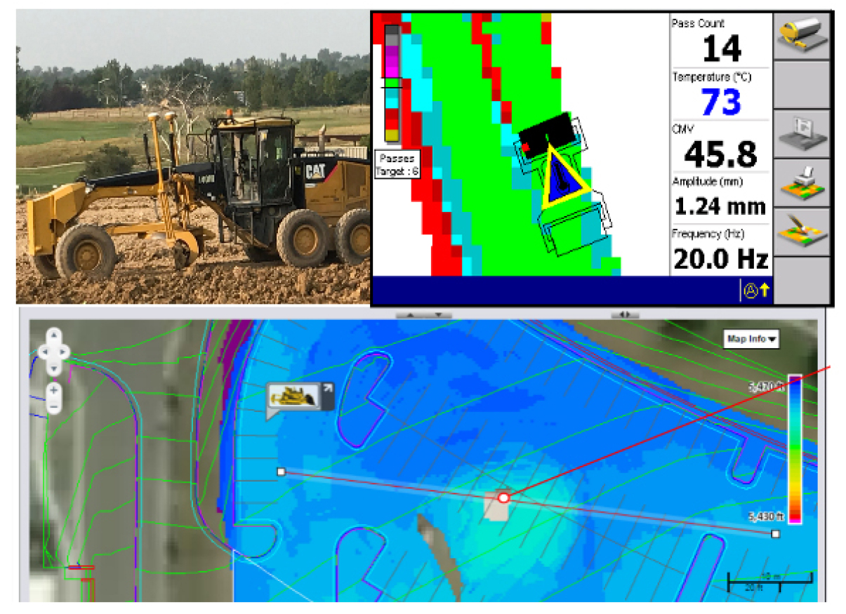
Smart construction is centered on the global market, and only private companies are investing, developing and commercializing it. Among them, construction equipment companies and surveyors, like Caterpillar Inc. and Trimble in the U.S., and Komatsu and Topcon in Japan, are working together to commercialize smart construction equipment and solutions. In addition, as shown in Table 2, various hardware and software are commercialized, ranging from 3D topographic data generation to post processing, 3D modeling and design. In particular, it can be confirmed that solutions are provided in the form of a three-dimensional construction information model in which data from hardware and software are fused. It can be seen that Autodesk and Trimble products are widely used in the global market in creating 3D construction information models. In particular, the products of the two companies, which have been commercialized, show that they are used in the form of a 3D construction information model that combines 3D topographic data and design drawings. It was found that the data form used LandXML provided by the OGC standard. It can be seen that the 3D construction information model is also applicable to the development of smart construction technology and products used by private companies.
Table 2.
Smart Construction Tools and Data
As mentioned above, it can be confirmed that countries and private companies around the world share a 3D construction information model that combines topographic data and design drawings in the smart construction stage of construction. However, there are no clear procedures or methods for creating a three-dimensional construction information model, so it is expected that there will be many restrictions when application and application are required. It is difficult to determine what equipment to use when producing step-by-step request data, and whether the requested data can be produced or exchanged with the equipment in hand. Therefore, it is necessary to define a series of procedures and methods from the design stage of smart construction to the design, and the form of deliverable generated by each procedure.
Design Methods for Creating 3D Construction Information Models (Proposed)
Role of 3D Construction Information Model Based on Smart Construction Procedures
The smart construction procedures are defined as shown in Table 3 by combining the contents defined in Sections 2 and 3 with the results of the investigation and analysis. In order to carry out smart construction, the basic design is carried out by creating and collecting data such as 3D topographic survey and ground data, and modeling the results in 3D. Cost calculation and review analysis are performed based on basic design data, and detailed design is performed based on that data. Detailed design will involve calculating construction costs, establishing industrial plans, and establishing industrial plans will be planned.
Table 3.
Smart Construction Process
Based on the implementation design data, a position control system is established at the construction site for automated construction, and the automatic construction of construction equipment is applied first to civil engineering work. When civil engineering is completed, automation of buildings and structures will be carried out, especially from the point of view of precision construction rather than automation. Once the construction process is completed, the construction and maintenance procedures will be implemented.
In this smart construction process, the 3D construction information model plays the following role.
First, virtual construction site information is provided, in which detailed design data in three dimensions, including topographic data, are fused. It will play the same role as a digital twin, and will perform the overall management of construction projects such as accurate project cost calculation, process management plan, safety evaluation of structures, equipment operation plan and management.
Second, for automated construction, information such as construction areas is provided to computers installed in construction equipment and automatically supports construction in conjunction with sensor information searched by construction equipment.
Third, this model compares the information obtained by surveying with the construction information from construction equipment and provides real-time information for construction quality inspection.
Finally, if design changes are required, direct product changes are made from this model and can be applied immediately to automated construction, which can quickly respond to various problems at the construction site.
Methods of Creating a 3D Construction Information Model
As shown in 4.1, the creation of the most basic and highly utilized 3D construction information model in smart construction is generated at the design stage, and the procedures and methods are the same as in Table 3.
And the 3D Construction Information Model Process is shown in Table 4. In order to create a three-dimensional construction information model, three-dimensional topographic surveying is carried out first. In order to ensure accuracy, GNSS measurement is carried out in principle. For areas where GNSS measurement is not possible, the three-dimensional coordinates of GNSS measurement are obtained by using GNSS measurement or national reference points.
Table 4.
3D Construction Information Model Process
These reference points will be used as reference points for three-dimensional topographic survey and will also be used as positioning services for autonomous operation of construction equipment during automated construction. The three-dimensional topographic survey mainly uses laser scanners on the ground, optical cameras using unmanned flying devices, and equipment equipped with rider sensors. In addition, data obtained through conventional measurements such as aerial imaging can be used simultaneously. Measurement data obtained in this way are obtained in the form of Leicester data representing topographic information, point clouds representing 3D information using point groups, and vector data.
The measurement data obtained in this method is large in capacity and there is a lot of unnecessary information, so the necessary information is retained and the capacity is reduced. This work can be called GIS processing and drawing preparation. Through this process, map-shaped data such as numerical maps and authentic historical maps will be used. These data are lower in capacity than those obtained by surveying and contain only the necessary information, so they have the advantage of being easy to analyze and process.
These data are represented by basic 2D information, but attributes and graphics have 3D information, based on which 3D modeling is performed. When we do this, we’ll transform it into a three-dimensional map like Google Maps or CityGML that we can see in V World. However, data in the form of a three-dimensional map are provided for visualization purposes and cannot contain information about IFC-based drawings. In other words, it means that it cannot be linked to the design drawings created by 3DCAD, which are currently widely used in design.
Conversion of 3D construction information models must therefore be carried out, which can be fused with the design drawings or supported to enable the design of these data. The results will be represented in LandXML format, and the data generated in this process will then be available for baseline, cost calculation, implementation (detailed) design, automated construction and quality control, completion and maintenance.
Conclusion and Recommendations
Currently, including Korea and other countries around the world are actively promoting practical technology research to improve productivity by digitalizing construction drawing information and automating construction equipment. This study defines the three-dimensional construction information model, which is the most basic and highly utilized form of smart construction, and presents the data form. This definition is expected to prevent confusion by summarizing terms that have previously been different in areas such as architecture, civil engineering, and surveying. Furthermore, the role and utilization of 3D construction information are presented, and the detailed procedures and methods for producing 3D construction information are defined. Therefore, it is expected that the user’s understanding and usability will be improved by providing a guide to the production, application and utilization of 3D data required for future smart construction introduction.
In the future, standards and methods for compatibility between IFC-based BIM data and LandXML-based 3D construction information models must be developed first. In particular, research on data exchange and transformation should be conducted because smart construction is expected to ensure free compatibility between various data as it changes to data-centered technology rather than manpower-centered technology.
