

Introduction
Smart city and urban digital twin
Study goals
Methodology
Data collection
Classification
Results
Urban digital twin applications
Classification of applications
Discussions
Conclusions
Introduction
With the rapid development of computing power and information and communication technology, the 4th Industrial Revolution has arrived. Big data, which is constantly occurring in various sources, is combined with the development of AI technology, and heralds a huge change in our society. For example, many factories are being automated under the name of smart factories, and autonomous vehicle technology, which is in full swing, is expected to completely change human lives.
In the field of urban studies, this trend is proceeding under the concept of a smart city. Many cities around the world are promoting smart city projects according to their respective definitions and contexts. While smart city projects appear in various ways in each city, attempts to create a virtual city modeled exactly like a real city in a digital space are being made in several technologically advanced cities. This virtual replica city is expected to be an important basis for smart city technologies to be applied or used in real cities; in Seoul and Singapore, virtual city services, called S-Map and Virtual Singapore, respectively, operate. This virtual city service is also called an ‘urban digital twin’ or ‘digital twin city,’ and is considered as one of the key technologies that constitute a smart city.
Smart city and urban digital twin
With the development of digital technology, the smart city concept has emerged as an alternative to complex and diverse urban problems, such as population growth, low birth rate, aging, low growth rate, environmental pollution, and resource depletion [1]. The limitations of urban functions due to rapid urbanization highlight the need for efficient urban management in all fields, such as energy, transportation, disasters, and the environment [2]. Since this phenomenon is expected to intensify worldwide in the future, there is a fundamental limit to solving the problems with the existing method of infrastructure expansion. Thus, the smart city concept has been attracting attention as a way to solve urban problems at low cost through the efficient use of existing infrastructure [3].
The smart city concept is defined in various ways according to different contexts, such as country, economic level, and regional and urban policies, which makes it difficult to summarize it as a single concept. However, the concepts commonly suggested in various definitions of smart city can be stated thus: ‘A sustainable city model that solves urban problems and improves citizens’ quality of life by applying new technologies such as big data and information and communication technology to cities as a way to efficiently utilize urban resources’ [1, 2, 4, 5].
A smart city has the characteristic of functioning as a platform that includes a wide range of elements related to citizens’ lives. In this regard, Kim et al. (2018) [1] looked at smart cities as a platform city where infrastructure, institutions, and human resources are harmonized. They explained that smart cities solve urban problems by analyzing information collected from all over the city and inducing efficient use of its resources; that is, the entire city becomes a platform that provides customized information required by its users.
The fact that a smart city has the characteristic of a platform that deals with the overall urban issues means that it can be described as a set of numerous individual elements. In this regard, Frost and Sullivan (2014) [6] selected smart energy, smart buildings, smart mobility, smart technology, smart healthcare, smart infrastructure, smart government, smart security, and smart citizens as the components of a smart city. Lee et al. (2016) [4] divided the detailed elements included in a smart city into smart networks, smart safety, smart transportation, smart economy, smart energy and environment, and smart welfare, and Kim et al. (2018) [1] demarcated the fields of smart city technologies as transportation, energy, environment, crime prevention, safety, industry, economics, and welfare. A classification of the detailed factors of smart cities is essential for the actual implementation. Yoon (2018) [7] introduced Singapore’s smart city action strategy and explained five factors of transport, energy, safety and security, environment and water resources, and built environment and city management. Cho and Oh (2017) [8] introduced a Korean smart city development strategy and presented elements, such as transportation, administration, health, welfare, environment, crime, and disaster in detail. Korea Telecom (2018) [2] described smart city-related services by dividing them into tourism, health, energy, water resources, environment, safety, and transportation.
A digital twin is a concept in which a virtual world created based on 3D modeling is connected to the real world, and real data are utilized in the virtual space and fed back to the real world [9, 10]. It is also considered as a simulation process for a physical product in a virtual space [11]. The pros and cons of various options can be identified through this simulation before taking an actual action on physical products [12]. Therefore, digital twins have the potential to be widely applied and used in various fields, such as manufacturing, space, aviation, automobiles, architecture, and medicine [10].
An urban digital twin is the application of digital twin technology to cities. Although this concept is also called as ‘digital twin city’ or ‘city digital twin’, in this study, ‘urban digital twin’ was used. Various aspects, such as housing, infrastructure, transportation, and energy are intertwined in a city, and urban problems occur in the complex interrelationships of each [9]. Therefore, an urban digital twin applied with digital twin technology in an urban space is a comprehensive technology system that cannot be composed of simple technology or a single application [13], and is considered a key element and starting point of a smart city [11].
In the urban digital twin, the actual urban space is reproduced in the same digital space; in the process, all the domains and systems of the city are reflected in this digital platform. In this virtual city, real-time interaction between physical reality and the virtual model takes place [14], including real-time monitoring of the city, analysis of various phenomena, prediction of the future through simulation, and visualization of various characteristics [9]. Through this interaction, policymakers can quickly and accurately understand the current state of the city at a low cost, and have the opportunity to predict the effect of the policy and respond to the situation before implementing the policy [15, 16].
It is expected that the digitalization of the entire city and the virtual simulation process through the urban digital twin will help planners solve the complex problems of the city [15]. In addition, the improvement of the city’s management and operation ability can lead to an improvement in citizens’ quality of life and the establishment of a sustainable city [14]. Therefore, the urban digital twin is recognized as an opportunity to upgrade urban planning and to develop successful smart cities [17].
Study goals
Urban digital twins are expected to be effectively utilized in urban planning, design, management, and operation as a core platform for a smart city. As a city is a space where numerous domains are intertwined and operated, urban digital twins have a wide variety of possibilities in their utilization. However, it is also true that urban digital twins are somewhat vaguely understood, as they are still in their infancy in terms of technology development and utilization. Finally, for those who operate or prepare the construction of an urban digital twin, a systematic understanding of its potential use is necessary to maximize its effectiveness.
Against this background, this study examines the applications of urban digital twins and their characteristics in detail by investigating various cases and literature. To this end, it 1) lists various functions and services that can be realized through the urban digital twin platform, and 2) attempts to deepen the understanding of individual items by classifying them from various perspectives. It is expected that this study will have many implications for constructing an urban digital twin and establishing its application plan.
Methodology
Data collection
In this study, to investigate the applications of urban digital twins, a related data search was conducted using several keywords. Keywords for data search included not only ‘urban digital twin’ but also the terms ‘digital twin city’ and ‘city digital twin.’ Additionally, based on the fact that the digital twin concept itself is being described as a platform for simulation through virtual models, keywords such as ‘urban simulation’ and ‘city simulation’ were also used. The simulation work on the phenomenon taking place in urban space was, in principle, judged acceptable for the urban digital twin platform.
This study utilized various types of data to present as many possible applications of urban digital twins. First, academic papers on the keywords presented above were read. Second, literature in the form of news articles or web articles was referred to. Third, public documents published by public institutions were used. Finally, the explanatory materials of private companies related to urban digital twins or urban simulation services were used.
Classification
Various criteria were defined to classify the applications of urban digital twins. Since a city is a space in which numerous domains are comprehensively intertwined, many urban problems are difficult to solve with a simple analysis or approach. An advantage of the urban digital twin is that it can serve as a platform that helps solve urban problems by considering the complex interrelationships of various fields. Therefore, the subject of the application was the most basic classification criterion.
Urban digital twins have various applications; therefore, it is necessary to prepare a model that meets the purpose of each application [10]. As the direction of the model development will be determined from the beginning according to the final service type, the service type of application was selected as the criterion for classification. In addition, the scale of the space targeted by urban digital twin applications was selected as the criterion for classification. Urban digital twins rely on data from various layers of the city [15], and the solutions derived from them also have various application scales. Therefore, it is important to consider the spatial scale of urban digital twin applications in terms of data acquisition or solution utilization.
In addition, classification was performed in terms of operators and users of urban digital twin applications. Since the citizens and stakeholders in cities have diverse interests, in the field of urban planning, the participation and collaborative process of multiple actors as well as the various domains should be considered [18]. Therefore, in the digital twin of the public sector, such as city governments, the roles of the public or private sector need to be well defined [10]. In addition, since the urban digital twin can be a platform where stakeholders such as policy makers, engineers, and citizens can discuss together [9], it is also important to classify and organize its applications from the user’s perspective for a systematic understanding of urban digital twin applications.
Results
Urban digital twin applications
Table 1 presents the results of this study. It lists the 40 investigated applications of urban digital twins, and brief descriptions of each item are provided. During the investigation process, many cases were found, in which content hierarchies appeared variously among the applications, or the content overlapped vaguely, but these were summed up by the authors. Applications with comprehensive functions are excluded as much as possible, and the individual contents of the applications are revealed. There are applications that are already being used in real cities, such as Seoul, Singapore, and Hangzhou, and also items that are being proposed as potential applications or are being performed in city-related simulation works. In this study, all of these items were judged as potential applications of urban digital twins.
Table 1.
List of urban digital twin applications
Classification of applications
Classification by subject
The urban digital twin applications were classified into six subjects. The first is applications related to urban planning and design. There are many forms of applications predicting the impact through simulation prior to planning actions, such as urban development and building permits. They provide information necessary for policy decisions by simulating various factors, such as changes in land use according to urban development, the housing market, the occurrence of vacant houses, landscape, sunlight, and noise. Figure 1(a) shows a simulation of the impact of the new construction in Dublin. The second is applications related to city management and operations. In relation to physical infrastructure, simulations for building management using Building Information Modeling (BIM) or for supply and management of public infrastructure, such as water and sewage systems, common ducts, and street lights, can be performed as shown in Figure 1(b) of Hong Kong. In terms of city operation, techniques, such as monitoring security and simulations for predicting crime and efficient waste disposal, have also been introduced in London and Hangzhou.
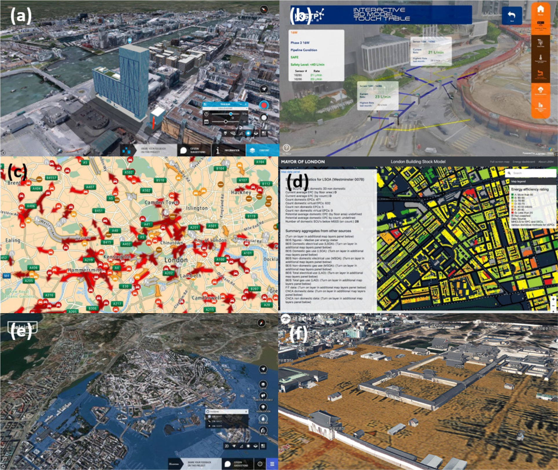
Figure 1.
Examples of urban digital twin applications by subject.
(a) Urban planning and design: Simulation of the impact of new building construction on shading in Dublin [19]. (b) City management and operation: Monitoring pipe infrastructure operations in Hong Kong [20]. (c) Transportation: Provision of traffic flow information in London [21]. (d) Environment and energy: Evaluation of building energy efficiency in London [22]. (e) Disaster: Flood simulation in Helsinki [23]. (f) Other use: Provision of tourism information (reproduction of past shapes) in Seoul [24].
The third is applications related to transportation. In terms of transportation planning, it is possible to simulate the effects of new roads or bridges on traffic flow. To reduce traffic congestion, simulation or information offering on traffic flow is performed (see Figure 1(c)); a simulation of public transit operation is also done. The responsive plan in emergency situations, such as various accidents, can be simulated in the traffic aspect. Urban digital twins can also be a platform for on-demand services for parking spaces and shared personal mobility, such as bikes and scooters. The fourth category is applications related to the environment and energy. In urban digital twins, the occurrence of an abnormal climate can be simulated in advance, and specifically, the simulation of urban heat islands or wind paths can be performed as in the case of Seoul. In terms of energy, it can be used to predict the amount of solar power generation or as an analysis platform for a smart grid system that comprehensively considers energy consumption and supply. Figure 1(d) shows the evaluation of energy efficiency for each building in London.
The fifth is applications related to disaster. Simulation of natural disasters, such as floods and wildfires, can be used to prepare countermeasures against them in advance (see Figure 1(e) for the Helsinki case). It can also become a platform for information sharing and predictive simulation to control contagious diseases. In relation to fire accidents, it is possible to optimize the route choice of the fire engine and simulate the fire scene response method using building data. Finally, there are various other ways in which urban digital twins can be utilized. In Seoul, they play an important role in city tourism when combined with advanced technologies, such as VR, as shown in Figure 1(f). Urban digital twins can also be used as platforms for various sharing economies, as is done in Singapore.
Classification by service type
Urban digital twin applications are classified into four service types. First, in most cases, urban digital twin applications provide simulation services for policy decision-making. As a digital twin is basically a simulation platform, simulation services are provided in various applications of all subjects related to cities. Figure 2(a) shows a simulation of the wind paths in Seoul. Second, urban digital twin applications provide real-time monitoring and analysis services. In urban digital twins, data are collected in real time from numerous information sources within the city. By monitoring and analyzing these data in real time, it is possible to quickly respond to emergencies in the city. Data from various fields, such as transportation (see Figure 2(b) for Seoul), environment, energy, and public security were collected and analyzed.
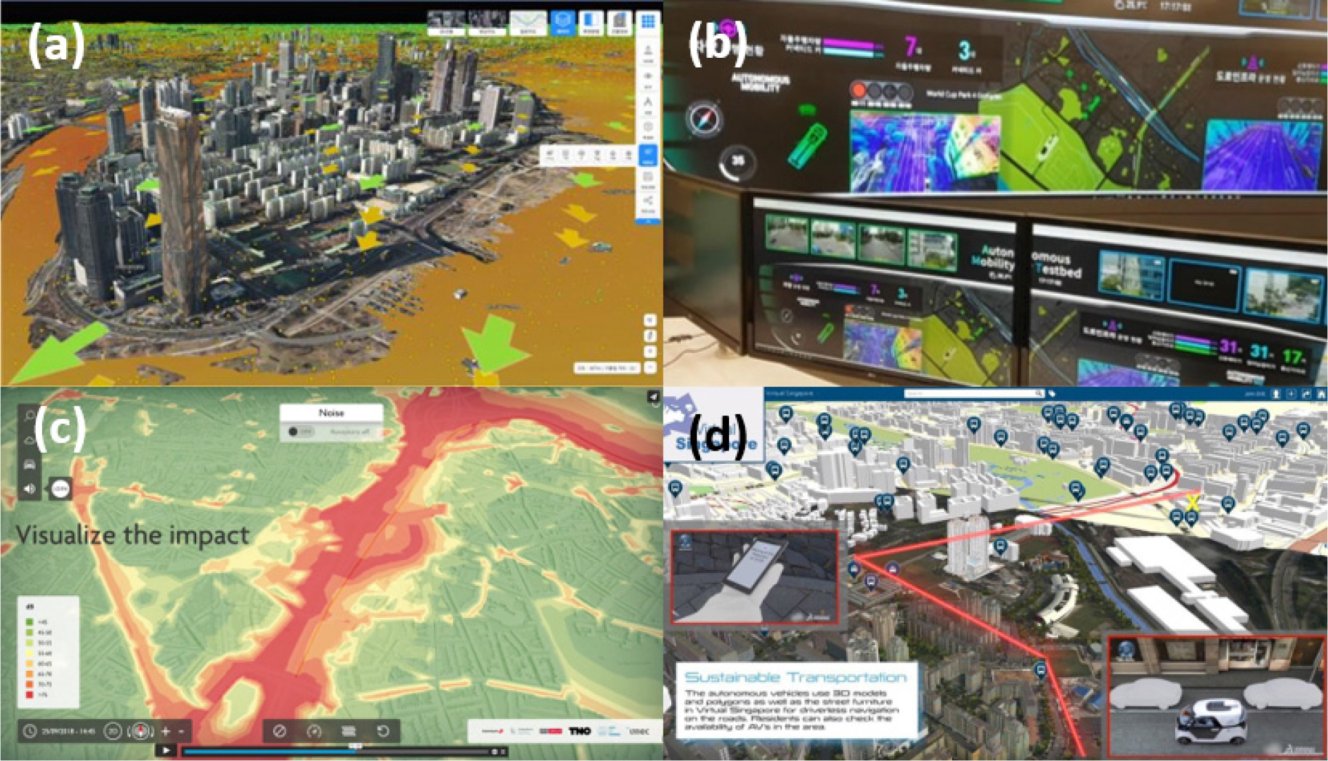
Figure 2.
Examples of urban digital twin applications by service type.
(a) Simulation: Simulation of wind path in Seoul [25]. (b) Real-time monitoring and analysis: Traffic condition monitoring in Seoul [26]. (c) Mapping and database construction: Mapping of noise level in Antwerp [27]. (d) Civic service: Shared car platform service in Singapore [28].
Third, urban digital twins can be used for various mapping and database construction related to cities. A vast amount of data is accumulated in an urban digital twin. These data are sometimes reborn as new and important information through the visualization process after mapping, or may be constructed as a database and used effectively in the future. Figure 2(c) shows a visualization of the noise level in Antwerp. Finally, various services can be provided directly to citizens through urban digital twins. The urban digital twin can provide information necessary for citizens, such as traffic conditions and various daily life information in real time, and can be used as a platform for various sharing economy services, as can be seen in Figure 2(d) of Singapore’s sharing car service.
Classification by spatial scale
Urban digital twin applications are classified into four spatial scales. First, at the building scale, various simulations related to the building were performed. As information is collected and utilized based on BIM, as shown in Figure 3(a), it is necessary to establish a system for this purpose. The second is urban digital twin applications used on the street scale. Applications related to transportation are mainly implemented on this scale. These applications are expected to help improve the efficiency of urban street networks. As in the case of Figure 3(b), the risk of traffic accidents can also be predicted for each segment of the street.
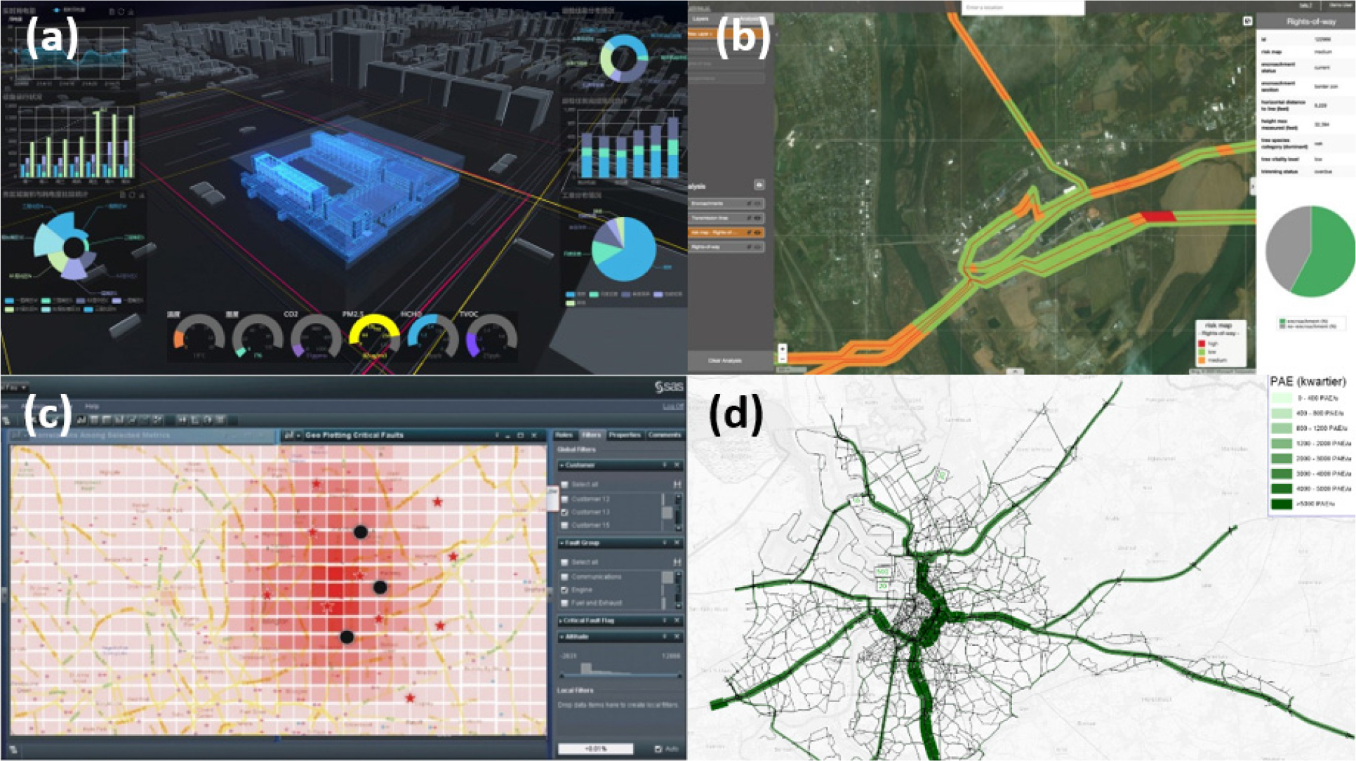
Figure 3.
Examples of urban digital twin applications by service type.
(a) Building scale: Building information management [29]. (b) Street scale: Prediction of accident risk by street section [30]. (c) Neighborhood scale: Prediction of crime level by city district in London [31]. (d) City scale: Urban street network analysis [32].
The third is urban digital twin applications on a neighborhood scale. This is a case where local area-level analysis is required, such as the urban heat island phenomenon. As a lot of statistical data is collected in administrative units, the spatial unit of information generated through urban digital twin applications can also be an administrative unit. Figure 3(c) shows the prediction of crime levels in each city district in London. Finally, urban digital twin applications can be examined on a citywide scale. Regardless of the spatial unit in which data is collected, in many applications of urban digital twins, data are collected for the entire city. Urban digital twins can be an essential platform for applications that require analysis on a citywide scale, such as simulations of urban land use changes, green space changes, smart grids, and whole city road networks (see Figure 3(d)).
Classification by operator and user
Urban digital twin applications are classified into three types according to the relationship between the operator and user. Unlike other digital twins, urban digital twins are built based on a vast amount of public data, so the public role as an operator is required for all applications. This notion relates to the fact that urban planning, management, and operations are fundamental in the public sector. Under these conditions, the first configuration is an application in which the public sector is both an operator and a user. As the main service of urban digital twins is the simulation of various policy decisions of the city government and real-time monitoring, the urban digital twin applications used by the public sector have been investigated the most.
Second, there are urban digital twin applications in which the public services are directly connected to citizens. Various kinds of information related to living in a city, such as transportation, can be provided to citizens through urban digital twin platforms. In this case, citizens simply become users of the service. However, urban digital twins can be used as a forum in which citizens actively participate rather than simply be passive users. Applications, such as a real-time reporting system for various accidents and infrastructure failures and a system for participating as evaluators in building design competitions, are being introduced in Seoul.
Third, the public provides the urban digital twin system as a mediating platform for services sold by private companies to citizens. Since urban digital twins function as a platform for various simulations, the private sector can provide various services using the platform. For example, many private companies are already running shared mobility services. When these services are combined with urban digital twins, better quality services can be provided through the use of various kinds of additional information, as attempted by Sejong. In addition, more efficient services can be provided in connection with private companies in the field of building and infrastructure management.
Discussions
The characteristics of digital twin applications being promoted in cities around the world. So far have been examined in terms of service subject, service type, spatial scale, and operator and user terms (see the appendix). The main characteristics of each category are discussed below.
First, in terms of the subject of digital twin services, 17.5% is urban planning and design, 17.5% is city management and operation, 27.5% is transportation, 15.0% is environment and energy, 12.5% is disaster, and 10.0% is other uses. Digital twin services on various topics have been promoted to date. It was found that services necessary for planning and design processes, such as estimating housing (U3), land use demand (U7), and landscape simulation (U4), were proposed, and monitoring and simulation techniques (T1, T10, T11) for efficient use of roads were suggested in the transportation field. It can be seen as an application proposed to solve problems that require precise estimation through large-scale data simulations on topics that are difficult to estimate using traditional methods.
Second, by the service type, 39.3% is simulation for policy decision-making, 34.5% is monitoring and real-time analysis, 10.7% is mapping and DB construction, and 15.5% is civic service. The current digital twin can be understood as a decision-making tool that monitors the real world, collects data, analyzes it in real time, and verifies the effect of policy through simulation based on the collected data. Since this is the early stage of digital twin application, it can be seen that a service that observes the real world and collects data, and a service that utilizes it for policy decision-making, are being developed first. Although limited, services such as a platform (C2) in which citizens participate in the urban planning process are provided, so that the citizens can utilize the digital twin applications.
Third, let us look at the characteristics of digital twin services according to a spatial scale. The digital twin service, which defined the spatial scale by city units, is 29.9%, followed by street unit services at 26.4%, building units at 23.0%, and neighborhood units at 20.7%. Digital twin services are promoted on various spatial scales, such as buildings, streets, and cities. Relatively, it can be seen that the promotion of services by neighborhood units is insufficient. Building unit services are implemented centered on simulations such as sunlight (U6), noise (U5), firefighting (D3), and indoor ventilation (E2); urban units include environmental simulations, such as wind roads (E6) and heat islands (E5); and public transportation policies, such as shared bicycles (T8) and electric kickboards (T9). It is implemented as a service related to civic life, such as waste prediction (C7). It is regrettable that digital twin services receive relatively less attention than buildings, streets, and cities on the neighborhood scale in the urban planning design field. To improve the quality of space and living, it is necessary to develop various digital twin applications in neighborhood units.
Finally, in terms of operators and user, public to public is 59.3%, public to citizen is 25.9%, and 14.8% are public to private. In most of these cases, the public is the subject of operation and use of the digital twin, and public-private cooperation and citizens have not emerged as the main actors. Owing to the high construction cost and difficulty of the digital twin service, operators and users mainly appeared in the public sector. Various digital twin services are promoted, such as the pilot projects, so it is understood that the public sector takes these risks first.
Based on the analysis of the digital twin application being discussed in cities around the world. The future direction of digital twins will be deliberated on in terms of their applications, such as problem solving, participation platforms, and incremental scale-up. Based on the characteristics of digital twins as per the application subject, service type, operator and user, and spatial scale, we present three implications, considering the strengths and weaknesses of the current digital twin service.
Digital twin applications as problem-solving
The urban digital twin is applied to various fields, including database construction, environment monitoring, and simulation on various topics, such as urban planning and design, transportation, environmental energy, urban management, and disaster prevention. A large volume of data is required to build such an urban digital twin system, and the cost of building the system is also high. At a time when the digital twin system is not yet widely distributed, the system as a total solution may raise concerns about its effectiveness.
Therefore, it is necessary to build a digital twin system as a problem-solving application to address urban problems rather than a system as a total solution. Approaches, such as tactical urbanism, in which short-term actions lead to long-term permanent changes, or lean development, which is clumsy but is implemented first and then perfected through optimization, must be applied in order to build urban digital twin systems. In other words, it is necessary to apply digital twin applications in a way that focuses on the problem, provides a problem-solving service, and increases the perfection of the systems. Urban digital twins should be developed as applications to handle problems that cannot be solved by existing applications, and problems that can be measured and evaluated through simulations that have not been calculated because of their high cost.
Digital twin applications as participation platform
It is common for the public sector to build the world of urban digital twins using public data. The public sector is also one of the representative users of urban digital twins. The system is mainly used to simulate the policy effect in the digital twin world for policy decision-making by the city government, and then to apply the verified policy to the real world when a positive effect is obtained.
However, the approach of such a digital twin is not different from expert-centered or top-down decision-making in terms of pursuing efficiency and rationality emerged as the main values after modernism. The rational comprehensive planning approach is based on efficiency and rationality, and has caused various urban problems. It showed limitations in not being able to effectively manage various conflicts in the urban planning design process. Alternative planning theories, such as progressive planning theory, advocacy planning theory, and participation planning, have been proposed. As we have seen in various cases of urban digital twins, it is limited to a service that simply provides information to citizens or a third-party service by sharing it with the private sector. This fact emphasizes that the effectiveness of digital twins limits citizen participation and is highly likely to follow the top-down method of the past. Therefore, urban digital twins should be applied as a platform for citizen participation or the public-private partnership by considering not only efficiency but also equity, fairness, and transparency, as in alternative theories.
Digital twin applications as incremental scale-up
If we look at urban digital twin application cases on a spatial scale, the scale and scope vary from buildings to cities. BIM applications have already been developed and utilized in buildings. BIM is a comprehensive and systematic information management system that collects information on the life cycle of a building, such as materials, planning design, construction, and supervision. Geographic Information System (GIS) programs, such as ArcGIS and QGIS, which can handle two-or three-dimensional spatial data, are widely used for neighborhoods and cities. Compared to BIM and GIS, an urban digital twin has the advantage that it can be used for various purposes, by integrating spatial data of independently operated buildings, neighborhoods, and cities into one system. However, it is not cost-effective to build a digital twin system that covers all spatial scales from buildings to cities. Sufficient computing power is required to run this system, and manpower to build and operate is also essential. Therefore, a cost-effective approach is needed to maximize the social utility of urban digital twins. It is necessary to build a system toward the direction of gradually increasing the scale, by reinvesting based on social consensus after the utility of the urban digital twin is verified, starting with a spatial scale that is easy to construct and operate.
Conclusions
This study collected a total of 40 cases of urban digital twins that are being promoted in many cities by focusing on digital twin cases among the core pillars of a smart city, and then clarified and characterized the subject, service type, spatial scale, operator, and user as major variables. Recently, as the discussion of digital twins has been active and the number of practical applications has increased, it has become possible to analyze their characteristics. In addition, the future direction of the urban digital twin was discussed from three perspectives. However, there is a limit to the fact that invisible cases that are not searchable were not reflected, other than the 40 digital twin cases covered in this study. It is also necessary to expand the discussion on successful urban digital twins by updating recent cases that were not reviewed in this study, because digital twin technology is expected to develop incrementally in future.
Appendix
