

Introduction
Water Courses and Urban Areas
Cachoeiro de Itapemirim Urban Development
Assessment and Diagnosis of Valley Bottom Occupation in Cachoeiro de Itapemirim
Final Considerations
Introduction
The municipality of Cachoeiro de Itapemirim is the main economic hub in the South of the State of Espírito Santo, it has an estimated population of 189.889 inhabitants according to the 2010 census. Its territory is totally within the Itapemirim river basin. The town developed along the river’s banks in its last navigable point, from the river's mouth.
Changes in the natural environment are intrinsic to urbanization but the intensive and irregular occupation in the areas at the valley bottom caused several impacts on the water resource and also in man and nature relationship. The removal of the ciliary forest, the water contamination, the soil sealing besides the rivers bed change are facts that can generate changes in the water dynamics. So, through field research this paper tries to analyze the forms that the occupation of the valley bottom of Itapemirim river in Cachoeiro de Itapemirim’s urban area.
The bibliography investigation tries a further theoretical-conceptual in relation to the object studied, analyzing authors that debate the main thoughts on the subject. Maps, figures, satellite images, old photos, found in government agencies files were examined besides existing reports and analyses.
Amorim & Cordeiro’s (2004) methodology was used on the chosen object of study, which serves as a parameter to identify the relationship of the environment and the urban environment. Through this diagnosis, grants will be provided to find solutions to minimize the environmental impacts of urbanization and to sustainable development in valley bottom areas.
Water Courses and Urban Areas
In Brazil, the formation of cities has the constant presence water bodies. The characteristics of the physical site and landscape were crucial to the emergence of urban nucleus. The rivers, streams and creeks by means of its ecosystem resources, were used as source of subsistence and circulation of people and merchandise, besides its main component - water - is an indispensable source for living beings. The rivers also keep in themselves aspects related to the place’s memory and identity, and they perform a relevant cultural and environmental role.
From the 1950s, with the growth of industrialization and expansion of urban areas, the conflicts between development and the physical environment were added, causing several impacts on the water environment and a landscape disqualification process. This agglomeration in cities, the lack of a really effective planning and inefficient management, resulted in a quality loss process and great impact in the environment issues, with the water, air, soil and vegetation degradation (GORSKI, 2008).
In 50 years (1950 to 2000) there was an increase of 45% of the population living in urban areas, according to the Brazilian Institute of Geography and Statistic (IBGE), and according to the 2010 Demographic Census 84,35% of the Brazilian population lives in cities, in absolute numbers 160,879,708 people.
However, with the start of environmental discussions and the limits of exploitation of nature new issues and alternatives were proposed. The Brazilian Forest Code in Article 2, requires the allocation of the banks of water bodies with non-built lanes; they are called Permanent Preservation Areas (APP). This is a legal mechanism for protection of vulnerable environmental areas, such as rivers, springs, hill tops, steep slopes, marshes, plateaus and other. For the rivers, the APP’s lanes are established by the width of the river’s bed. Since their creation in 1965 the APP”s had their limits increased on two occasions, in 1986 and in 1989 that are in force to today. These limits range from 30 to 500 meters from the river bed biggest part and around the springs a radius of 50 meters should be considered.
This impediment of any form of use and occupation of riverbank areas establishes a paradigm of confrontation, between the urban parameters and environmental parameters, as pointed by Mello (2008).
Thus, the first paradox underlying the theme is set: on the one hand, the multiple urban functions and the attraction that water bodies have on people; on the other hand, he legal device that prevents the formal occupation of the banks of water bodies in Brazil, aiming the preservation of its environmental functions (Mello, 2008, p. 39).
However, the legal provision that prevents the formal occupation on the banks of water bodies has also proven inefficient, for the management of water resources in cities transcends static view of preservation, as states Mello (2008).
Costa (2006) added that one of the major conservation factors is visibility, the more the water is hidden, the easiest to pollute and embank. The collective and equal ownership of these spaces is needed, so a feeling of belonging and social life is generated.
Addressing these paradigms, due to their complex character, assumes an urban sustainable development, as stated by Tucci (2008) aims to enhance the population’s quality of life and environmental conservation.
It is also essential to integrate as quality of life is only possible in a conserved environment that caters to the population’s necessity, guarantying harmony between man and nature (TUCCI, 2008, p. 97).
Cachoeiro de Itapemirim Urban Development
Cachoeiro de Itapemirim is a municipality with its own life, industries, farms and trade that support itself. Moreira (2004) when referring to the city's evolution describes it as a simple trading post, a ranch troops, a humble port of canoes for loading and unloading of farmers, adventurers and mule drivers, which became a city, commercial hub, and then political state and a culture converging point (Moreira, 2004).
The village developed on the banks of Itapemirim, with colonization from upstream and vessels being forced to halt due to the rapids that hinder navigation, by Baiminas and on the north side, across from what should have been the Cement plant, currently disable. The first houses in the municipality were built and later on became an important economic hub, mainly due to the use of Itapemirim river as a as river transport for passengers and to flow products such as timber, coffee, sugarcane, which were transported to the port of Barra (Caetano, 2014, p.25).
The 21 City’s Agenda (2005) describes its economic development. During the sugar cane period Cachoeiro do Itapemirim did not develop a lot, remaining the same XVII Century settlement, when some pioneers tried to settle in the region aiming exploration of gold that supposedly existed in Castelo.
Only after 1850 with sugar decline, by its price national discrediting, Cachoeiro began to prosper due the agricultural expansion process, led by coffee that generated the wealth of that time.
Due to the great demand of coffee transport, Itapemirim river became insufficient, and to meet this need, Caravelas (1887), Leopoldina Railway (1903) e Estrada de Ferro Itapemirim (1926) were built, not only contributing but also transforming the natural landscape of the city. (CAETANO; DIAS, 2013, p.6)
Because of the facility of rail transport Cachoeiro absorbed Itapemirim River’s economy becoming an urban center of high importance. According to historians, in 1902 the city was the third in the country and first in the state to have electricity by installing a power plant on the Island of Light.
During that period of agricultural expansion, the dynamics in rural properties always followed the same logic based in three stages: 1) deforestation with the sale of the noblest wood and cutting down of the remain wood (that was burned); 2) coffee planting taking advantage of the natural fertility of the soil, and 3) replacement of coffee plantation by pastures when the coffee crop was shown unproductive (AGENDA 21, 2005).
From the eighties to the present, the most resourceful branch of the city’s economy is that of mineral extraction, classifying the municipality as The Capital of Marble and Granite. The consolidation of this segment, combined with the centrality gained between the nineteenth and twentieth centuries, reflecting on trade and service center, besides an expressive local industry, keeps Cachoeiro’s economic momentum (AGENDA 21, 2005).
However, these same activities that boosted the city's economy are responsible for the environment degradation. According to agenda 21 Local (2005), these activities caused: removal of native vegetation, including the river sources and banks, soil degradation due to inadequate model farming, siltation and pollution of streams and Itapemirim River with pesticides, and especially domestic and industrial sewage. The disordered urbanization of the municipality and road construction is also another component in this disqualification process. Intense deforestation with the removal of riparian vegetation, the vegetation that there is on the river banks, and the irregular occupation of the slopes, together with land slope enhanced the process of erosion of the water body. Before navigable, the Itapemirim river today has an average depth of 1 meter and a half.
Assessment and Diagnosis of Valley Bottom Occupation in Cachoeiro de Itapemirim
According to Amorim (2004), there are different methods and techniques that can be used to investigate environmental impacts. From the research on these methods and techniques the author subsidized the elaboration of the methodology, in this instance, specific to the assessment of the occupation of urban valley bottoms.
Amorim & Cordeiro (2004) methodology was based in a preliminary research, where 12 environmental criteria were established, which tried to guide the planning of the occupations that border water bodies, involving, for example, recognition of the hydrologic cycle, stimulus to the occupation with compatible features to the possible occurrence of flooding, avoidance to soil sealing, maintenance of riparian forests, connecting green areas favoring biodiversity, consideration to the topography, avoiding modification of watercourses, encouraging the coexistence of the population and the aesthetic and landscape improvement. As a consequence, to these environmental criteria, 15 assessment parameters are generated having physical, biological or anthropic characteristics. These parameters give rise to evaluation forms, that have to be used in stretches of the bottom valley, with homogeneous characteristics of occupation. There are three columns on the forms: the first with the parameters and their subdivisions, the second with the score assigned to each parameter (5-1 point where number 5 is the ideal situation and the number 1 the worst situation), and the third column for meaningful comments. The parameters used in the assessment forms are: type of bottom of valley occupation, soil permeability , presence of native riparian vegetation, presence of reforested areas, interconnectivity, water quality of the watercourse, flooding and urban flooding, siltation of the watercourse, erosion of the banks of the watercourse, change in topography, change in the course water, concerns to the incident legislation, permeability of the river basin, degree of identification and appreciation by the population and aesthetics and landscape quality.
Amorim (2004) recommends that the filling in the forms must be done in loco, through observation and conversation with the locals, and that photographic diagnosis of excerpts be done. The author also advices on the use of additional information such as: maps, aerial photographs, data obtained from government agencies, etc. The result of the attained score with the assessment identifies the status of each area and point out the main potentials and obstacles. Also, you can check the proximity level between the scored parameters and the criteria, which are the reference for the desired sustainable development (AMORIM, 2004).
The choice of Amorim & Lamb method (2004), in addition to its easy implementation and low cost, is justified by the fact that the established parameters, present themselves in a clear and specific form. Junqueira (2008), when commenting on the method, adds that the parameters are as quantitative as qualitative. However, he notes that on the quantitative flexible measurements are not accurate and map able made, as on the definition of permeable areas and on the qualitative, as the aesthetic quality and landscape, there is a high degree of subjectivity (JUNQUERIA, 2008).
Amorim (2004), also identified the three main occupation typology of bottom of valley, found in Brazilian cities and systematized iconographic material for each one. Type 1 is characterized by accentuated soil sealing, because of the absence of riparian vegetation, most of times, and by intense urban appropriation of the banks. Yet Type 2, soil sealing is smaller, and there are the green areas such as parks and recreational areas. Finally, Type 3, presents smaller negative impact on the environment, by presenting large presence of native forest, but difficult to adapt to urban areas (Amorim, 2004). But the author, to apply the method to the object of study, did not identify, for each assessed segment, the previously established typologies.
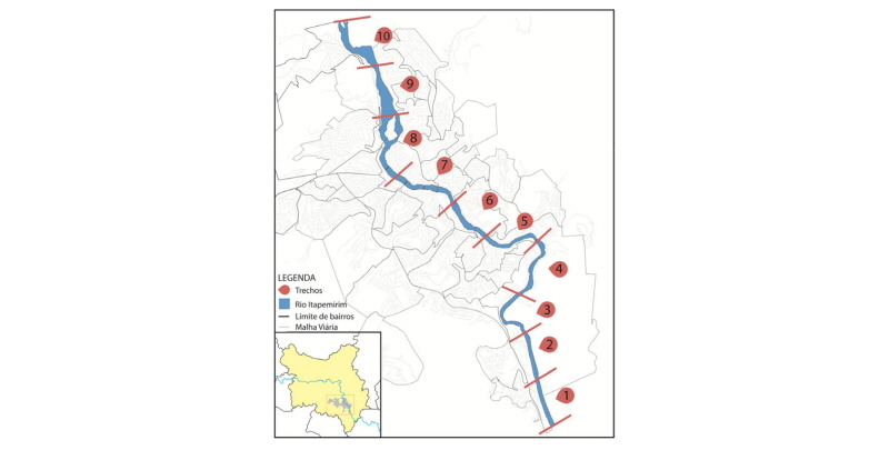
In this study, about Itapemirim river, some changes in the method were made. First, the urban area to analyze in Cachoeiro do Itapemirim was divided in ten sections of about 1000 meters. They were also marked marginal tracks about 100 meters from the bed of watercourses. This marking uses as reference the Brazilian Forest Code resolution.
Due to have adopted the field visit as technique for registration and examination of river Itapemirim valley bottom occupation by the municipal headquarter, the amount of parameters was reduced from fifteen to nine and specific occupation type for each segment was included, from the iconographic material proposed by Amorim (2004). Thus the seven parameters excluded, not possible to define correctly only from field trips are: water quality in watercourses, flooding and urban flooding, silting of the watercourse, erosion of the banks of the watercourse, alteration of the topography, permeability of the river basin, degree of identification and appreciation by the population. For the same reason, parameters three and four (presence of native forest and presence of reforested areas) were reduced to one, considering the “presence of riparian vegetation.”
This article analyzes and describes in general the main features found, based on the evaluation forma filled on the field, of the ten sections of the urban area having as guidance the seven parameters.
Through the diagnosis was possible to identify that all the sections fall into the Type 1 defined by Amorim (2004), however, with six subparts from A through F.
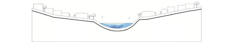
Type 1: Characterized by intense urban appropriation of the valley bottom, especially marginal avenues or paved streets, plots / buildings and informal settlements. The watercourse has been identified in two distinct situations: unmodified, in natural condition and modified by rectification, canalization or covering (AMORIM, 2004, p 100.).
Considering the first parameter, type of bottom valley occupation, Cachoeiro do Itapemirim is characterized by the intense urban appropriation of river bank areas, highlighting: marginal streets/avenues, plots/buildings, path/tracks without pavement and grazing area/cattle raising. In five sections (1 to 4 and 10), the bottom valley is occupied by streets and plots, but still keeping part of the riparian vegetation. But this vegetation coating, in its majority, are grazing area that represent only 8% of soil sealing capacity.
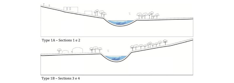
There has been intense soil sealing, with 60% of the entire area getting above 50% waterproofed. As to the presence of riparian vegetation, half of the sections show less than 25%. Sections 6, 7 and 8 show worrisome levels, with the absence of riparian vegetation and connected sections. In relation to the water course modifications two main occurrence were classified: without modification and modified by rectification. It is important to note that any element related to urbanization of the banks modifies the river path. But this study only considered as change in the watercourse, the extreme situation, the landfill of a stretch of the Rio Itapemirim, for the construction of Av. Beira Rio.

|
Figure 4. Type 1D - Sections 7 and 8. Beira-Rio Av. on the left bank. Source: Amorim (2004), modified by the author. |
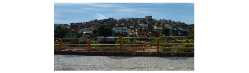
Even though great part of Itapemirim river still maintains its curvy characteristics, all urban area examined is occupied at least in one bank either by the road system or by constructions. It is also observed that 5 of the sections located in the center of the urban area, have both banks occupied mainly by unifamiliar housing with the back of the plots to the river banks.
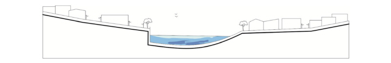
As an example, 1C type, in sections 5 and 6, refers to the one that makes the river more distant from the population. The buildings turn their backs to the river, and difficult to see it, only possible by slots between the lateral spacings - rare- and on the crossing points from one bank to the other

Considering the banks occupations, none of the sections meets the incident legislation, in this case the Forest Code, as the 100 meter preservation area is not respected.
For the last examined parameter, landscape and aesthetics quality, although subjective, the criteria used was related to the extent of vegetated areas, observing that the larger their number the greater the aesthetics and landscaping quality. In this case it was also considered the existence of sidewalks areas where a greater relationship with Itapemirim river is possible as in sections 7, 8 and 9.
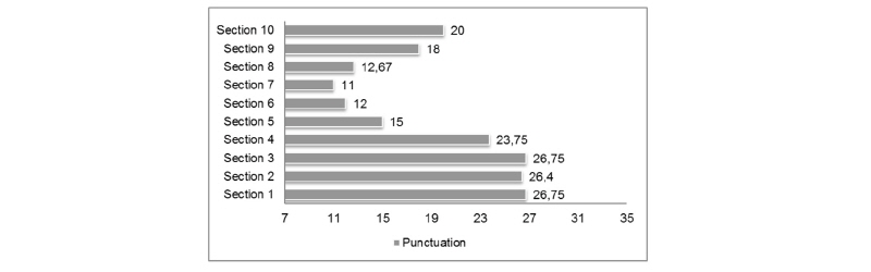
From filling in the evaluation forms a final grade was given to each section, following variation from 7 to 35 points, from the worst to the best condition, respectively. As Amorim says (2014, p.203), “the result of the grades given to several parameters allows to compare the environmental situation of several sections”. Thus, figure 8 shows a graph of the total score.
The final average for the sections is 19,23 points, lower than the average evaluation condition that was 21 points, what shows a really bad environmental condition. The biggest negative impacts were observed in sections 5, 6, 7, 8. The best scores are in the initial and final sector from the course demonstrating that the closer to downtown the worst the score is and consequently the environmental conditions. This finding becomes important for the possibility of planning the proper ways to occupy these expansion areas that minimize the environmental degradation and enhance the potential of the region.
Final Considerations
Through the time the uses and appropriations of Itapemirim river in the town of Cachoeiro do Itapemirim were modified according to the needs of each period. Early marked by the stage of navigability, mainstay of the region and mainly incorporated to the town’s daily life, nowadays the water body is seen as an element that tends to be forgotten, behind the buildings due to the gradual privatization of its banks
This article tried to demonstrate that the articulation between the environmental and urbanistic parameters is essential for the discussion about the forms for occupying the river banks. It is believed that from a study that addresses the particularity of each region a valorization and incorporation of the rivers in the cities will be reached as well as an sustainable urban development.
