

Introduction
Historical Context of Cuenca
Urban Identity and Morphology
Methodology
Historical Spatial Relationship of Cuenca with the Tomebamba River
Cuenca in the Twentieth Century
Cuenca in the Twenty-first Century
Changes in the Perception of Users of the Tomebamba Riverbanks
Uses of the Tomebamba River
Perceptions associated with the Tomebamba River
Natural environment of the Tomebamba River
Built environment and the Tomebamba River
Discussion and Conclusions
Introduction
The construction of identity related to resilience can be understood through human-environment relationships. By studying and exploring human behaviors, perceptions and spatial configurations, one can suggest socio- environmental improvements and better urban regeneration strategies (Cheshmehzangi & Heat, 2012). In this context, the study of the relationship of the city with its rivers is important because accessibility to water resources has played a key role in the location and growth of human settlements, being significant to the historical development of cities and the definition of the urban landscape.
Despite its importance, in many cities around the world the relationship between rivers and their cities has weakened (Novotny, 2009) so it is urgent to rediscover the potential of rivers and streams in the urban fabric (Beja da Costa, 2009) and its role as a public space capable of strengthening social resilience, understood as the ability of a group or community to recover or respond positively to a crisis (Maguire & Hagan, 2007).
In the case of Cuenca, rivers have played a key role in its development. This paper studies the historic relationship between urban dwellers and the river, in 1.5km of the Tomebamba River that runs in front of the Historical Centre of Cuenca, through uses and perceptions of its users. A series of semi-structured interviews were explored using discourse analysis, word frequency, and spatial visualization, to reveal perceptions associated with places and space morphologies, and how they have changed through time. The end goal of this work is to define the interrelation between morphology and perception, and the way it generates urban identities.
Historical Context of Cuenca
Cuenca is located south of Ecuador, in the Andes, 470km south of the equator, at 2.530 meters above sea level. Four rivers run through the city: Tomebamba, Yanuncay, Tarqui and Machángara. The Tomebamba River has its headwaters in the Cajas National Park, a moorland and wetland ecosystem that contributes to the water recharge, providing high quality water for cities in the Andean Highlands and parts of the coastal plain (Buytaert et al., 2006; Serra & Hermida, 2015). The city is located on an alluvial cone, in which three river terraces can be distinguished morphologically at different levels. The first, tallest of the three, corresponds to the hills of Cullca, north of the city. The second or middle terrace, is where the central part of the city is built, and the third and lowest, corresponds mostly to the southern bank of the Tomebamba River. The Yanuncay and Tarqui rivers run through the latter (Vicuña, 2000).
Cuenca and its predecessor settlements, Guapondelig and Tomebamba, have always maintained a close relationship with the water. The Spanish foundation took place in the Inca and Cañari city, on the intermediate fluvial terrace, north of the Tomebamba River. In 1947 the city expanded south of the riverbank, on the lower platform, with the implementation of the Urban Plan, by architect Gilberto Gatto Sobral. Since then, Cuenca has experienced expansive growth, passing from 288,29ha in 1950 to 7.248,23ha in 2010 (Hermida et al, 2015). Geographical corridors marked by rivers and streams determined this growth.
In 1982, through the Urban Development Plan of the city, local government showed interest in riverbanks (Jaramillo, 1982) situation that resulted, years later, in the generation and improvement of linear parks adjacent to the rivers. However, these spaces have not been resolved as part of a comprehensive network of urban green.
Urban Identity and Morphology
The importance of urban spaces for identity has been acknowledged since the 60’s (Bernardo & Palma-Oliveira, 2016). Identity refers to the distinction between certain elements from the whole, its recognition as a separate entity (Lynch, 1960), however identity can also refer to the relationship between elements with another. Urban identity made up of different components; socio-economic structure, socio-cultural structure, built environment and urban image (Murzyn-Kupisz & Gwosdz, 2011; Yaldiz et al. 2014). The first two can be analyzed through perceptions and uses of space, while the last two can be summarized as spatial morphology. Accordingly, the identity in an urban environment is defined by space and the activities and events that take place.
Morphology refers to the relationships between different elements; it is based on the idea that “the way things are assembled matter” (Hillier, 1996). The morphology of a city is reflected in a hierarchy of different sub-centers or groups along various scales, from the city to the suburbs, organized around different economic functions (Batty, 2008). Urban morphology provides us with valuable information about the structural characteristics of a city; it gives insight into the structural origins and impacts of historical change on the chronological processes concerning the construction and reconstruction of a city (Ariza-Villaverde et al. 2013). Morphology can be studied through road network connectivity, buildings, and diversity of land uses, which provide information on urban patterns influenced by the growth of the city under various urban plans and regulations and different socio-economic contexts.
The urban environment is characterized by the embodiment of certain kinds of identities in space, while space is dematerialized into non-discursivity and therefore into identity and culture (Hillier, 1996). Consequently the relationship between human behavior and perception with the urban environment can be studied; this relationship is linked to memory, culture, knowledge and emotions and generates urban identity.
Methodology
Historical maps, which identified changes in patterns of use and connectivity, were consulted to analyze the spatial morphology in relation to the Tomebamba River over time. References and historical texts, poems, and songs about the Tomebamba River, that provided important information regarding uses through history, were also reviewed.
Semi-structure interviews were employed to obtain information about the historical and current perceptions of the Tomebamba River. The historical perception had two types of informants: town historians and elders (70-85 years old) who lived their childhood, adolescence and youth by river Tomebamba. The current perception was also obtained with two types of informants: residents and users of the Tomebamba River, which are not necessarily the same people. The interviews were digitized, enabling their explorations through discourse analysis, word frequency and spatial visualization with Atlas.ti by QGis.
The information obtained from interviews and its relation to the analysis of changes in the spatial morphology of the city over time, allowed looking at the historical and spatial context of the city in connection with activities linked to the Tomebamba River, providing knowledge to understand the relationship between uses and the configuration of the city over time.
Historical Spatial Relationship of Cuenca with the Tomebamba River
Cuenca in the Twentieth Century
During the period 1900-1910, the axis of the Tomebamba River was the division between the consolidated and the expansion area of the city, called El Ejido. Two bridges served as entrances from the south and east of the city, basically intended for the use of pedestrians and carriages. In 1912, with the arrival of the first car, the planning and inhabiting of the city changed (Carpio, 1976).
In this period, the river was perceived by people as a means of sanitation of the city, sewage was transported by canals passing through the streets and flowed into the Tomebamba river (Vega, 1997), In addition, the height and abundant river flow were used by the population for productive purposes (Morales, 2011). From colonial times until the first decades of the twentieth century, the mills on the banks of the Tomebamba River started emerging and gaining importance in grinding wheat for flour production.
The banks were not considered as public spaces for leisure and recreation, yet close to them, on the south bank of the river, facilities, such as the hospital, the morgue and the nursing home, all of them public, had been installed (Albornoz, 2008). In this same bank the slaughterhouse had been built and used the river for the evacuation of its waste (Jamieson, 2003).
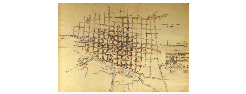
Between 1910 and 1930, the connectivity between the northern and southern riverbanks increased, with the construction of two new bridges: Mariano Moreno and Centenario (González & García, 2016). The buildings near the river began to have greater value so many of them were renovated and changed their traditional colonial style, to make way for the Republican; this happened in parallel with economic growth in the region, given by the export of toquilla straw hats, also known as Panama Hats (García & González, 2016). Each of these houses had secondary accesses that directly linked to the Tomebamba River (Figure 1). By 1930 the canals that moved sewage into the river were concealed (Vega, 1997) and at the same time, the number of hydraulic mills that were used for grinding wheat increased, transforming the area into the seed of the industrial region of Cuenca (Vega, 1997).
Since 1950, the southern area of the Tomebamba River began to urbanize consolidating and increasing the connecting of the middle terrace to the lower one. Along the northern bank, streets emerge to join the east-west ends of the city (Carpio, 1976). A great river flooding, precisely on 1950, caused the destruction of three of the five bridges that crossed the Tomebamba. According to Carpio the local traffic was affected for several years. Together with bridges, the slaughterhouse was destroyed and later relocated downstream. Despite this event, the educational facilities, parks and public squares, and hospital were maintained and augmented in the southern area of Tomebamba River (Albornoz, 2008).
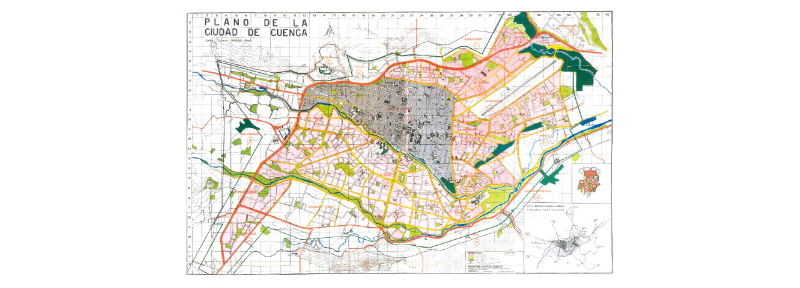
By the year 1970 (Figure 2) the green areas along the riverbanks became public spaces (Albornoz, 2008). Traditional building systems were replaced and consequently the materiality of the buildings in the area changed, allowing taller buildings of three or more floors (Carpio, 1976).
Cuenca in the Twenty-first Century
In this century, the largest investments were aimed at roads and automobile connectivity; underpasses were built on the southern riverbank. For non-motorized mobility three new footbridges were constructed (Zeas, 2013) and, on the northern bank, infrastructure for pedestrians and cyclists was built.
The use of the Tomebamba River as a production site was significantly reduced due to the disappearance of the mills. Traditional uses, such as “bathing” in the river and “trout fishing” were almost none and the presence of the washerwomen was maintained, although in a lesser degree (García & González, 2016. Novillo, 2010). Meanwhile, in view of the magnitude of the problem of contamination of the riverbeds by the discharge of wastewater, the public company in charge of water treatment of the city designed plans for its management.
The slope formed between the intermediate terrace (Historic Center) and the lower terrace, traditionally known as “El Barranco” does not lose its iconic character, it remains a quaint place suitable for cultural, artistic and sporting activities, also extending its use for night activities; with the presence of commercial premises, hotels, bars, restaurants, nightclubs, among others.
Due to the expansion of the city, the Tomebamba River is no longer a limit and has become part of the central urban area, where walking, wandering and sightseeing are daily activities for both locals and tourists that visit the city.
Changes in the Perception of Users of the Tomebamba Riverbanks
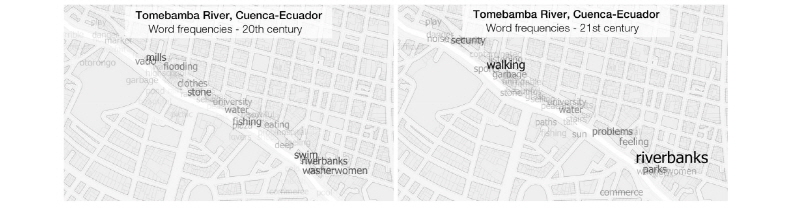
In-depth interviews offer another look at the changes in the uses and perceptions that have occurred in the Tomebamba River over time. Keyword counts were made on the transcriptions of the interviews using Atlas.ti that revealed diachronic differences in the relationships of citizens with the river.
One hundred keywords that relate to four dimensions of the study were selected: uses of the Tomebamba river (26 words), perceptions (42 words), natural environment (11 words), and built environment (21 words). Different variations of these words between interviews that referred to the mid-twentieth century and the twenty-first century were recorded based on their relative frequency. As seen in Figure 3, there are differences in the presence of words in the two analyzed historical moments.
Uses of the Tomebamba River
There are six words that show important differences between the two sets of interviews. In the mid-twentieth century: swimming, fishing, eating and washerwomen, while in the twenty-first century: walking and sports. The frequency of words indicates that uses of the Tomebamba River during the twentieth century were related to the water, with the exception of the word eating, while uses in the twenty-first century relate to the riverbanks. The word eating refers to picnics that were done frequently in the riverbanks in the twentieth century and is returning slowly today.
|
Figure 4. Tomebamba River use. Comparison of relative frequency of words between mid-twentieth century and early twenty-first century. |

Perceptions associated with the Tomebamba River
The words associated with pleasure, dislike, safety and environmental sensations also show important differences. In the previous century words that refer to positive perceptions, such as beautiful and like, and others that refer to negative perceptions like rubbish, horrible and danger, standout. The latter refers to the dangers related to natural phenomena such as flooding, not criminal activity. The words that predominate today are safety and noise. The first refers to the presence of criminal activities along the river that have been reported by respondents, and the second to motorized traffic taking place in the adjacent streets.
|
Figure 5. General perceptions of the Tomebamba River. Comparison between mid-twentieth century and early twenty-first century: relative word frequency. |

Natural environment of the Tomebamba River
Four words contain the main contrasts in relation to the natural environment of the river. In the previous century words like flooding, stones and deep-water predominate, clearly linked to water and, particularly, with the riverbed. In contrast, today the word riverbank predominates. This opposition expresses a difference in the use of the river, before more related to water, and now more closely linked to the banks. In fact deep-water and stone refers to the practice of 'getting into the river', jumping from a high stone to deeper water areas.
|
Figure 6. Perceptions on the natural environment linked to the Tomebamba River. Comparison between mid-twentieth century and early twenty-first century: relative word frequency. |

Built environment and the Tomebamba River
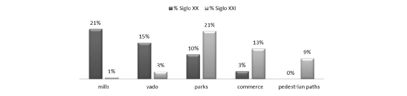
The words that show more contrast in relation to the built environment are mills, vado, parks, commerce and pedestrian paths. In the twentieth century words like mills and vado were more present. The word mill refers to the use of the river as a means of production, providing energy by spinning stone mills that were used to grind wheat, barley and corn. The word vado is related to a representative place that connected the two riverbanks and was part of the road that transported people to the south of the country. Currently the words parks, commerce and pedestrian paths are present, all referring to activities that take place on the riverbanks or on the immediate environment, and even though parks and pedestrian paths existed in the previous century, its presence in the imagination of people is intensified today.
Discussion and Conclusions
The identity relationship of a city with its main river is close-nit, and the city of Cuenca is no exception. In both periods analyzed the river frames the city and becomes a highly valued element by its inhabitants. Access, parallel roads, bridges and green spaces that have been built around and on the river have contributed to greater relationship and sense of belonging of the city inhabitants. Therefore, we can say that the way in which the space around the river is 'built' is crucial to the way we relate to it and contributes in the construction of identity of the place.
The main changes in perception regarding the river arise precisely through the uses it allows, and the uses that we allow ourselves in relation to it. In the mid-twentieth century the identity of the river was determined mainly by the water because of three consideration: first the water was a means of production that provided hydraulic power to move mills and generate electricity, and as a means of getting rid of solid and liquid of city; secondly the river was a fun space for bathing and collective games; and lastly there is the consideration of the river as a barrier, as a boundary separating the productive zone from the inhabited area, the rural from the urban. In contrast, at the beginning of the twenty-first century the identity of the river is determined mainly in the use given to its banks as a social meeting place between different people and for economic exchange.
The changes that public spaces like the Tomebamba River undergo cannot be understood isolated from its context. The production system of the city has changed from a subsistence agricultural model to one based on services and high value-added production. Public spaces are places of encounter and exchange of ideas and have a potential to increase the social capital and productivity of a city, a subject worth exploring in greater depth in future research.
